index overview file for lastile?
55 views
Skip to first unread message

Martin Thorhauge
Mar 28, 2022, 4:44:04 AM3/28/22
to LAStools - efficient tools for LiDAR processing
Hi
I am using lastile to split up large las files. I would also like an output file with grid index (Shp/dwg/dxf?) so i know where each tile is placed geographically.
Is this possible in las tools?
Please guide me if so :)
thanks
Regards
Martin

Terje Mathisen
Mar 28, 2022, 4:59:27 AM3/28/22
to last...@googlegroups.com, Martin Thorhauge
Martin, this really isn't needed!
When tiling, LAStools will by default name the tiles with (typically UTM) orthogonal coordinates, i.e. like this:
tile_288512_6597120_256.laz
for a tile of 256x256 meters located at 288512E, 6597120N which (since the zone is 32N) is located in Haugesund on the south-west coast of Norway. In this particular case, the souce data for the tiling contained the UTM header info which the tile inherits:
variable length header record 1 of 2:
reserved 43707
user ID 'LASF_Projection'
record ID 34737
length after header 51
description 'by LAStools of rapidlasso GmbH'
GeoAsciiParamsTag (number of characters 51)
UTM sone 32, basert p EUREF89 (ETRS89/UTM)|NN2000|
OK?
Terje
Martin Thorhauge wrote:
--
Download LAStools at
https://rapidlasso.de
Manage your settings at
https://groups.google.com/g/lastools/membership
---
You received this message because you are subscribed to the Google Groups "LAStools - efficient tools for LiDAR processing" group.
To unsubscribe from this group and stop receiving emails from it, send an email to lastools+u...@googlegroups.com.
To view this discussion on the web visit https://groups.google.com/d/msgid/lastools/52f38134-f8a6-43a7-95a9-952958b647adn%40googlegroups.com.
--
- <Terje.M...@tmsw.no>
"almost all programming can be viewed as an exercise in caching"

Michał Kuś
Mar 28, 2022, 5:33:06 AM3/28/22
to last...@googlegroups.com
Hi Martin,
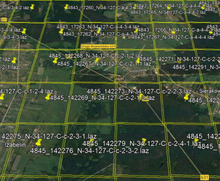
to easily preview extense of las tiles I use command:
lasboundary -i *.laz -o overview.kml -overview -labels -use_bb
If projection is not specified within laz files, I also need to add -epsg switch
I have attached a small example of output as seen in Google Earth.
Best regards,
Michal
--
Reply all
Reply to author
Forward
0 new messages