Skip to first unread message

david lapier
Jan 13, 2023, 7:25:01 PM1/13/23
to International Laser Class Association District 24, toshinari....@gmail.com
On 1/10, Toshi wrote, "..., I never thought
about the clouds when racing and I have been having no idea about how the
clouds affect the wind or the relationship between the clouds and the winds.
So, my question is: How the clouds affect the winds?"
Here is a Duckies and Bunnies answer for non-raining cumulus clouds (the puffy white ones) and for rain clouds. The reference is Frank Bethwaite, "High Performance Sailing", Chapter 8. Not covered here are cold-fronts or many other cloud-related topics of interest.
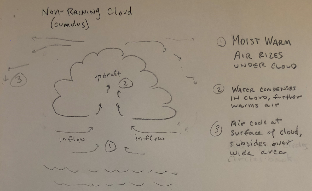
In non-raining cloud (cumulus) clouds, moist air is pulled in and up as it warms. The water vapor in the air condenses to form/build the cloud. Water changing from vapor (gas) to droplets (liquid) in the cloud gives off heat, which further warms the air, and encourages the further updraft. At the edge of the cloud cooling air drifts away over a wide area.
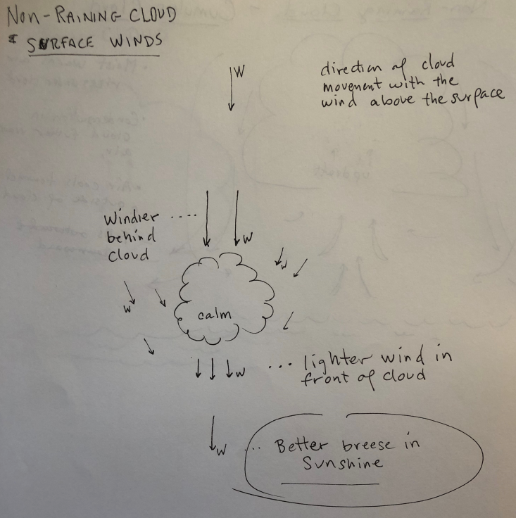
What does this look like to the sailor? It's windier in the sunshine and calmer under the cloud. Stay in the sunshine.
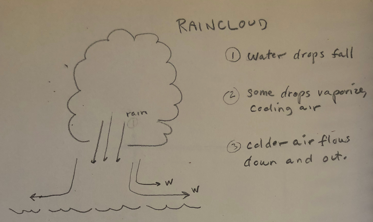
Rain Clouds are different. They are more or less the opposite of building cumulus clouds. As the droplets in the cloud fall, some of them vaporize (go from liquid to gas) which cools the surrounding air. The cold air sinks and spreads out across the surface. The bigger the rain cloud, in general the stronger and colder the downward and outward flow.
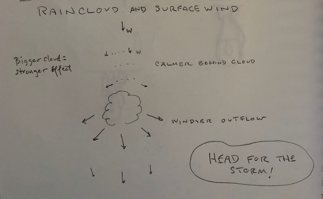
How does this outflow manifest itself at the surface? Stronger breeze in front and alongside the storm, nice lifts when sailing near raincloud and parallel to it on either tack. Lighter air behind the cloud. Head For The Storm!

Al Sargent
Jan 13, 2023, 7:48:16 PM1/13/23
to david lapier, International Laser Class Association District 24, toshinari....@gmail.com
David, great explanation, thanks.
Toshi,
Following up on David's point, the key is track the formation of the cumulus clouds via:
- Age of the clouds -- did they form an hour ago? Three hours ago? How much time passes until they "switch modes" form updraft mode to downdraft mode, and start dumping cold, moist air? (Sometimes this is rain, and sometimes this is just cooler breeze.)
- Time of day -- at what time of day do they clouds typically switch to downdraft mode? (Often this is mid/late afternoon, after the clouds have absorbed all the moisture they can hold.)
- Color of clouds when they're in updraft mode, and color when they're in downdraft mode?
Once you know that, you're just add/subtracting vectors like in high school physics. But it takes a lot of patient watching of clouds between races, mixed in with all your other pre-race todos like tuning, linesights, practice starts, hydration, etc.
(Because of this, good sailors see the time between races as just as important as the race itself; every moment should be optimized to be as prepared as possible. It's not a time to switch off.)
(Because of this, good sailors see the time between races as just as important as the race itself; every moment should be optimized to be as prepared as possible. It's not a time to switch off.)
High Performance Sailing is a great read. The author explains clouds in detail with memorable phrases like "fires in the sky". The author knows a lot; check out his background.
More resources on localized weather:
Lake convergence/divergence (a theory of why left often works in Huntington Lake and perhaps Crissey Field):
Good book to read:
Good videos:
Also see her attached PDF.
Hope this helps!
--
Discussion forum for International Laser Class Association - - ---District 24, covering northern California and Nevada. Topics should include all things (ILCA) Laser and not idle chit chat which should be taken offline from this forum. This site is rated PG.
To join this group, email international-laser-class-ass...@googlegroups.com
---
You received this message because you are subscribed to the Google Groups "International Laser Class Association District 24" group.
To unsubscribe from this group and stop receiving emails from it, send an email to international-laser-class-asso...@googlegroups.com.
To view this discussion on the web visit https://groups.google.com/d/msgid/international-laser-class-association-district-24/CABcrx2J3683pwqFmaNO%3D2uwt-0_RLW%3DeAYJYXWTndXAsfP38MA%40mail.gmail.com.

Takayanagi Toshinari
Jan 13, 2023, 11:12:12 PM1/13/23
to Al Surgent, david lapier, International Laser Class Association District 24
Thank you very much David for the theoretical explanation with good figures and also thank you Al for the additional useful information!
The way I was thinking was: clouds are just formed somewhere/somehow and they are just floating and pushed by the wind. But it looks the clouds are move live thing, causing the air circulation!
I watched a couple of YouTube videos Al suggested, which I found interesting. And it turned out that I actually have the “Wind Strategy” book written by David Houghton on my computer. It is just that I never read it ;)
Thank you very much for all the great information! There are lots of thing to learn, for which perhaps I could spend my time on in rainy weekends...
Toshi
<image.png>What does this look like to the sailor? It's windier in the sunshine and calmer under the cloud. Stay in the sunshine.
<image.png>Rain Clouds are different. They are more or less the opposite of building cumulus clouds. As the droplets in the cloud fall, some of them vaporize (go from liquid to gas) which cools the surrounding air. The cold air sinks and spreads out across the surface. The bigger the rain cloud, in general the stronger and colder the downward and outward flow.
<image.png>How does this outflow manifest itself at the surface? Stronger breeze in front and alongside the storm, nice lifts when sailing near raincloud and parallel to it on either tack. Lighter air behind the cloud. Head For The Storm!
<image.png>
--
Discussion forum for International Laser Class Association - - ---District 24, covering northern California and Nevada. Topics should include all things (ILCA) Laser and not idle chit chat which should be taken offline from this forum. This site is rated PG.
To join this group, email international-laser-class-ass...@googlegroups.com
---
You received this message because you are subscribed to the Google Groups "International Laser Class Association District 24" group.
To unsubscribe from this group and stop receiving emails from it, send an email to international-laser-class-asso...@googlegroups.com.
To view this discussion on the web visit https://groups.google.com/d/msgid/international-laser-class-association-district-24/CABcrx2J3683pwqFmaNO%3D2uwt-0_RLW%3DeAYJYXWTndXAsfP38MA%40mail.gmail.com.
<01ccc0_3436dfdc7d5f4b8982fd25b5b1660341.pdf>
Reply all
Reply to author
Forward
0 new messages