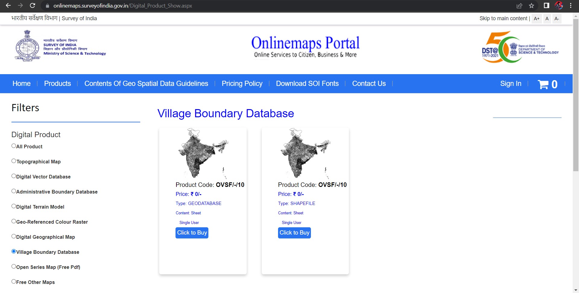
Survey of India published - District, Block and Village Boundaries
394 views
Skip to first unread message

Craig Dsouza
Sep 19, 2022, 6:16:28 AM9/19/22
to datameet
Hey,
has anyone written any scripts or downloaded & explored these?
It seems SOI is now publishing District, Block and Village Boundaries in vector formats for free

Justin
Sep 19, 2022, 8:26:01 AM9/19/22
to datameet
Great find! I am pretty sure you need a cell phone in India to actually create an account/ access?

chris mathen
Sep 19, 2022, 8:30:28 AM9/19/22
to data...@googlegroups.com
Yes otp send to mobile number
--
Datameet is a community of Data Science enthusiasts in India. Know more about us by visiting http://datameet.org
---
You received this message because you are subscribed to the Google Groups "datameet" group.
To unsubscribe from this group and stop receiving emails from it, send an email to datameet+u...@googlegroups.com.
To view this discussion on the web visit https://groups.google.com/d/msgid/datameet/314dca29-84d6-49c3-978f-7a1cc7befc45n%40googlegroups.com.

sreeram kandimalla
Sep 19, 2022, 8:37:21 AM9/19/22
to data...@googlegroups.com
Any download limits per day per user?
To view this discussion on the web visit https://groups.google.com/d/msgid/datameet/CAE7-%3D6Hnm0-CAzSm9EzV3Fhc8d9eV5GC%3D8HX%3D7ceVU%3DswmQchw%40mail.gmail.com.
Craig Dsouza
Sep 19, 2022, 9:55:34 AM9/19/22
to datameet
Seems like it yes.
--
Datameet is a community of Data Science enthusiasts in India. Know more about us by visiting http://datameet.org
---
You received this message because you are subscribed to a topic in the Google Groups "datameet" group.
To unsubscribe from this topic, visit https://groups.google.com/d/topic/datameet/JJ99n2NzeEU/unsubscribe.
To unsubscribe from this group and all its topics, send an email to datameet+u...@googlegroups.com.
Craig Dsouza
Sep 19, 2022, 9:57:05 AM9/19/22
to datameet
Sorry, i thought i was replying to Justin. I don't know if there are any download limits, except that you can only download one district at a time.

Sharad Lele
Sep 19, 2022, 9:35:55 PM9/19/22
to datameet
Thanks Craig for locating this dataset. Potentially solves all our problems. Yes, can add only one district at a time to the Shopping Cart, but can in theory keep going back and adding more items to the Cart (I did 2 at a time). Process for checking out and creating downloads involves many clicks... bit idiotic. But some substantive limitations after I downloaded and checked Dindori in MP:
1. Village boundaries do match latest village shapes from revenue layers, BUT they are east-shifted by 200m (they must have goofed the datum)
2. Polygons don't have any census ID, so linking to other data will require adding those manually (!!) or figuring out what numbering system SOI has used. Any thoughts on that?
3. I tried Andhra Pradesh two districts Vizag and Srikakulam, and it says "data not available yet". So the dataset is still in the making. Not sure what is available and what is not, overall.
Sharad
J M
Sep 19, 2022, 9:43:24 PM9/19/22
to data...@googlegroups.com
compiling here: https://github.com/justinelliotmeyers/INDIA_SOI_2022
To view this discussion on the web visit https://groups.google.com/d/msgid/datameet/05cf9776-56c0-40fa-9fcd-f19303c6d1bfn%40googlegroups.com.

Arun Ganesh
Sep 22, 2022, 12:31:22 AM9/22/22
to data...@googlegroups.com
For those interested in inspecting and cleaning up the data, there's been active discussion about it on the OpenStreetMap India group https://t.me/OSMIndia
You received this message because you are subscribed to the Google Groups "datameet" group.
To unsubscribe from this group and stop receiving emails from it, send an email to datameet+u...@googlegroups.com.
To view this discussion on the web visit https://groups.google.com/d/msgid/datameet/CAOLgkyrVaf8AwmUx_BNVGZSX9CPt_1HXGxCzaK8L5hmbU5ajyQ%40mail.gmail.com.

Prabhakar Rajagopal
Sep 27, 2022, 2:16:16 AM9/27/22
to data...@googlegroups.com
To view this discussion on the web visit https://groups.google.com/d/msgid/datameet/CA%2BGKQr1xztkdQKau2efVT-M47%2B3Wuf_kJe3NHUdFdbRFYf2YWg%40mail.gmail.com.

Sabyasachi Kabiraj
Sep 27, 2022, 4:54:01 AM9/27/22
to data...@googlegroups.com
1st login than you will able to download.
To view this discussion on the web visit https://groups.google.com/d/msgid/datameet/CABzdB7aYb8Zufo9GKSjf2o%3DVg_B4a3OXzp%2BrYbXjJ1QCamybbQ%40mail.gmail.com.

Devdatta Tengshe
Sep 27, 2022, 5:01:14 AM9/27/22
to data...@googlegroups.com
I had played around with this data a couple of days ago.
One Important thing to note is that count does not match either the one from LGD or the census.
For example, SOI has 4723 Sub Districts, while LGD has 7021.
Similarly, SOI has 742 Districts, while LGD has 763.
Regards,
Devdatta
To view this discussion on the web visit https://groups.google.com/d/msgid/datameet/CAMeiFgi_k77SqXudGUi1h1Dk%3DYmF7Ub3QANGQj3KUMWO1okb_Q%40mail.gmail.com.

Shubham
Sep 29, 2022, 4:37:37 PM9/29/22
to data...@googlegroups.com
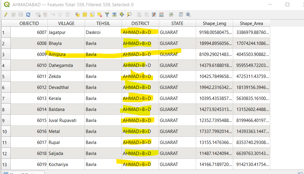
Just a note that there is a recurring mistake wherein random alphabets in names have been replaced by special characters like ">" or "@" etc. In the screenshot below, it looks like "a" has been replace by ">" but in other files ( I have checked Ahmadabad and Belagavi village boundaries ), there are different characters popping up and these are not limited to a certain column only.
Also there are no LGD codes mentioned so joining with other datasets will prove difficult.
Also there are no LGD codes mentioned so joining with other datasets will prove difficult.
To view this discussion on the web visit https://groups.google.com/d/msgid/datameet/CAMgvHC4-pY_AszsizHnY4U-m0OuO0%2BpWnELqjVNbxiss6GKqvA%40mail.gmail.com.
sreeram kandimalla
Sep 29, 2022, 4:46:23 PM9/29/22
to data...@googlegroups.com
Conversions from soi manuals..
">", "Ā"
"<", "ā"
"|", "Ī"
"\", "ī"
"@", "Ū"
"#", "ū"
"<", "ā"
"|", "Ī"
"\", "ī"
"@", "Ū"
"#", "ū"
To view this discussion on the web visit https://groups.google.com/d/msgid/datameet/CAEVPytRsfoPhr1rHCwuV1kbUzagFf4d5EySjw5Po%3DiiT0YdKpQ%40mail.gmail.com.

Blue Secret
Oct 17, 2022, 8:33:56 AM10/17/22
to data...@googlegroups.com
Hey! Do you have a reference of the SOI manual you took these from?
Thanks,
To view this discussion on the web visit https://groups.google.com/d/msgid/datameet/CAMgvHC7je1qq-3_8zZN2OoG405sFzR5qRmEW0CiKfCUGjNzzgA%40mail.gmail.com.
sreeram kandimalla
Oct 17, 2022, 10:33:10 AM10/17/22
to data...@googlegroups.com
To view this discussion on the web visit https://groups.google.com/d/msgid/datameet/CAO1f68ihuYg0UTkHvPSnAH%2BW%2B8VUFLGVutE9XbBuZ%3Dhxc%3D%3Dk5g%40mail.gmail.com.
sreeram kandimalla
Oct 17, 2022, 11:45:38 PM10/17/22
to data...@googlegroups.com
Given that the page I referred to in the previous mail renders like the image pasted below on my pdf viewer, it wasn't that simple to get the mappings out.
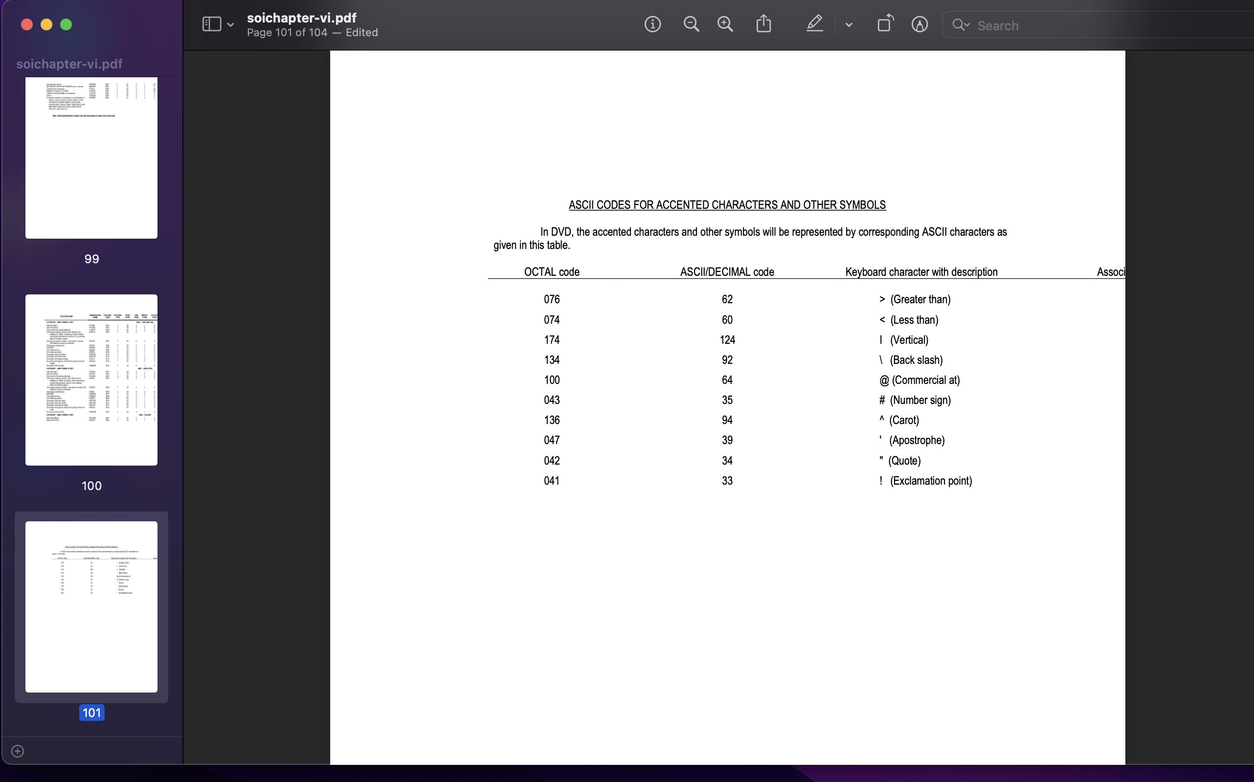
First I had to ascertain that there was data past the cutoff portion.
For that, I used http://brendandahl.github.io/pdf.js.utils/browser/
(This is a very handy tool for anyone who has had the misfortune of having to deal with pdfs that just won't render properly or won't get parsed properly.
A bit of knowledge of the pdf spec is needed. But, this tool has helped me debug a lot of pdf issues. I hope others find it useful too.)
After that I used "mutool trace" from the mupdf toolkit to get all the data in the page out as hierarchical xml and then proceeded to extract the previously invisible mapping data from that xml file.

Vaidya
Nov 1, 2022, 10:07:54 PM11/1/22
to data...@googlegroups.com
Many of the state-level district maps have been converted to kml and uploaded here.
District level village maps are here for 4 Indian cities and Goa:
https://data.opencity.in/dataset/villages-maps-for-major-cities-of-india
https://data.opencity.in/dataset/villages-maps-for-major-cities-of-india
Thanks,
Vaidya
Vaidya
--
Datameet is a community of Data Science enthusiasts in India. Know more about us by visiting http://datameet.org
---
You received this message because you are subscribed to the Google Groups "datameet" group.
To unsubscribe from this group and stop receiving emails from it, send an email to datameet+u...@googlegroups.com.
To view this discussion on the web visit https://groups.google.com/d/msgid/datameet/7ace1f9a-4842-4080-b71c-708b25730af7n%40googlegroups.com.
Reply all
Reply to author
Forward
0 new messages