River depth data all over India districtwsise
61 views
Skip to first unread message

Sabyasachi Kabiraj
Sep 9, 2019, 2:21:16 AM9/9/19
to data...@googlegroups.com
Hi friends, I am looking for river water depth data in India, particularly
in Maharashtra coastal regions, Can anyone help me regarding this?
...............................................................................................................
Sabyasachi Kabiraj
Senior Research Fellow
Central Institute of Brackishwater Aquaculture (ICAR-CIBA)
Santhome, Chennai- 28
Tamil Nadu, India
Contact No.: +91-7384774928, 8250259808

Craig Dsouza
Sep 9, 2019, 2:35:16 AM9/9/19
to datameet
try the ICESat/ ICESat2 dataset:
https://nsidc.org/data/atl13
accessible here as well https://www.openaltimetry.org/
--
Datameet is a community of Data Science enthusiasts in India. Know more about us by visiting http://datameet.org
---
You received this message because you are subscribed to the Google Groups "datameet" group.
To unsubscribe from this group and stop receiving emails from it, send an email to datameet+u...@googlegroups.com.
To view this discussion on the web visit https://groups.google.com/d/msgid/datameet/CAMeiFgiKbKT-pOC4nw1CMju0-%2B5_85mBte23BBFRyusRThRVgA%40mail.gmail.com.
Independent Researcher - Water Resources Management
Open Water Data Project
My Blog: https://craigdsouza.github.io/blog
Sabyasachi Kabiraj
Sep 9, 2019, 2:53:52 AM9/9/19
to data...@googlegroups.com
I went through the website but the elevation it is showing is not accurate.. can you please explain me how to derive the depth data from the website?
...............................................................................................................
Sabyasachi Kabiraj
Senior Research Fellow
Central Institute of Brackishwater Aquaculture (ICAR-CIBA)
Santhome, Chennai- 28
Tamil Nadu, India
Contact No.: +91-7384774928, 8250259808
To view this discussion on the web visit https://groups.google.com/d/msgid/datameet/CAFCtJgxV9se_XfX7qagMzk9UrjmNd1g0S4VVfFqCi-9Ti6sgDQ%40mail.gmail.com.
Craig Dsouza
Sep 9, 2019, 4:27:45 AM9/9/19
to datameet
sure, first can you explain what you tried? and why you say it is inaccurate?
perhaps share screenshots showing what you see vs what you expect to see
To view this discussion on the web visit https://groups.google.com/d/msgid/datameet/CAMeiFggT8p1bGOEqpTOZO82yGD4xVUOQ_PRrZhrjiBqQdo8HSw%40mail.gmail.com.
Sabyasachi Kabiraj
Sep 9, 2019, 4:45:16 AM9/9/19
to data...@googlegroups.com
I have seen point data of altimertry data in Maharashtra coastal region. But the river depth data is not available. It is only showing elevation data. Can you explain how to find the data. Here I have attached one screenshot please have a look on that.
...............................................................................................................
Sabyasachi Kabiraj
Senior Research Fellow
Central Institute of Brackishwater Aquaculture (ICAR-CIBA)
Santhome, Chennai- 28
Tamil Nadu, India
Contact No.: +91-7384774928, 8250259808
To view this discussion on the web visit https://groups.google.com/d/msgid/datameet/CAFCtJgx0oOkxzMxWZy5kLX8BhqLUH5619uK%3D4%3D2uNdBiWe7XkA%40mail.gmail.com.
Sabyasachi Kabiraj
Sep 9, 2019, 4:47:48 AM9/9/19
to data...@googlegroups.com
I need water depth data in metres. but here they have shown only elevation data not river depth data also if river depth data is available kindly please let me know how to check it. Thanking you.
...............................................................................................................
Sabyasachi Kabiraj
Senior Research Fellow
Central Institute of Brackishwater Aquaculture (ICAR-CIBA)
Santhome, Chennai- 28
Tamil Nadu, India
Contact No.: +91-7384774928, 8250259808
Craig Dsouza
Sep 9, 2019, 6:00:28 AM9/9/19
to datameet
hmm, ok, it seems the region you're interested in may be difficult.
the altimetry data is useful for river depth if there is some period during the year when the river runs dry.
in that case you can use altimetry data from two different timestamps, winter & summer to see the change in water levels.
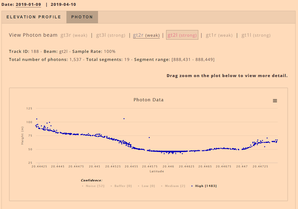
the image attached shows 'photon data' which gives you a cross section profile of river elevation for the month of April 2019.
but since the river isn't running dry it's hard to estimate the depth of the water
moreover, the west flowing rivers are narrow in the hills so that also makes it difficult to find a good profile
alternatively you can try the http://tamcnhp.com/wris/#/waterData (India WRIS) website.. this is being revamped so it doesn't show much at the moment
but it may in the future.. there again, you will get river gage level (in metres above MSL) not river depth directly
Reply all
Reply to author
Forward
0 new messages