NEW DISTRICTS OF INDIA SHAPEFILE
4,864 views
Skip to first unread message

akula.g...@gmail.com
Jul 11, 2022, 2:31:11 PM7/11/22
to datameet
Hi all,
I have updated INDIAN-DISTRICTS shapefile with all new districts even including newly formed Andhra Pradesh districts counting a total of 755 districts.
Regards,
Akula Guru Datta

Dammalapati Sai Krishna
Jul 12, 2022, 9:05:11 AM7/12/22
to datameet
Hello Guru Datta, Thank you very much for this effort!
Would you be able to share the source of this data? That would help us in using this data with proper quotes.
Also, as per the Local Government Directory there are 756 districts. Just want to bring it to your notice if you haven't come across this yet.
Thanks again!
Sai Krishna
Akula Guru Datta
Jul 12, 2022, 12:58:11 PM7/12/22
to data...@googlegroups.com
Hi Sai Krishna,
I made this myself by gathering various resources.
Thanks for your info on new district Tamulpur was missing. I will add it soon.
--
Datameet is a community of Data Science enthusiasts in India. Know more about us by visiting http://datameet.org
---
You received this message because you are subscribed to a topic in the Google Groups "datameet" group.
To unsubscribe from this topic, visit https://groups.google.com/d/topic/datameet/4kuQecxfEv8/unsubscribe.
To unsubscribe from this group and all its topics, send an email to datameet+u...@googlegroups.com.
To view this discussion on the web visit https://groups.google.com/d/msgid/datameet/4dcde696-df5a-4868-8ae4-3fd5e389ba3dn%40googlegroups.com.

Deepak Sharda
Jul 13, 2022, 5:09:39 AM7/13/22
to datameet
Great Work Dutta. You have always helping with your hard work on this platform. Is there a place where we can get updated villages shape files as well.
I tried merging updated village data from multiple sources. Not sure how accurate it is. Sharing sith you if you could help improving it on open platform.

Gurpreet Singh
Jul 18, 2022, 6:56:02 PM7/18/22
to data...@googlegroups.com
Hi Akula
Thanks for sharing the file. I am unable to upload it on Q-GIS. Can you please help me on this.
Or if you have shape file of the districts, you might like to share.
Gurpreet Singh
Gurpreet Singh
PhD - Food and Agribusiness (IIM-Ahmedabad)
M.A. Rural Development, Tata Institute of Social Sciences
B.Sc. Agriculture, G.B.P.U.A.&T., Pantnagar
“Stretching his hand out to catch the stars, he forgets the flowers at his feet” ~ Jeremy Bentham
--
Datameet is a community of Data Science enthusiasts in India. Know more about us by visiting http://datameet.org
---
You received this message because you are subscribed to the Google Groups "datameet" group.
To unsubscribe from this group and stop receiving emails from it, send an email to datameet+u...@googlegroups.com.
To view this discussion on the web visit https://groups.google.com/d/msgid/datameet/c586dac0-8513-4668-9eeb-d6181b7f1fc2n%40googlegroups.com.

Nikhil VJ
Jul 19, 2022, 3:08:17 AM7/19/22
to datameet
Hi Gurpreet,
Just checked; the INDIA_DISTRICTS.geojson file is loading on QGIS fine at my end. It's big, though.
The data is already split up by states in the same github repo - you can go into the states folder:
--
To view this discussion on the web visit https://groups.google.com/d/msgid/datameet/CAO3Acsh8dbPWS%3DsUzoFdm9KwW8Gu73wF1Aw3omhPfvp7mBCxrg%40mail.gmail.com.

devang majithiya
Jul 22, 2022, 7:03:20 PM7/22/22
to data...@googlegroups.com
Dear sir
Devang P Majithiya
I am trying to develop regional transportation network for particular region, where to get base shapefile from Google map ( road network) and how I can show specific route. Also if anyone know about networking, route Assignments in TRANSCAD , please let me know his contact details.
To view this discussion on the web visit https://groups.google.com/d/msgid/datameet/CAH7jeuN49VHdsq-tMLruT-RvTjKeKcU1vfi9KFNvKqOdFPmTkQ%40mail.gmail.com.

Akshit Shah
Jul 24, 2022, 2:40:42 PM7/24/22
to data...@googlegroups.com
Hi
Akula Guru Datta,
I cross checked the district file with the latest LGD district list and found there are 3 new districts formed recently which are missing from the file. Can you please add them. The District are namely
1. Tamulpur, Assam
2. Pakyong, Sikkim
3. Soreng, Sikkim
you can find the jurisdiction in the government order for these respective districts uploaded on the LGD website. Attaching the same here for ease of reference.
Warm Regards,
Akshit Shah
You received this message because you are subscribed to the Google Groups "datameet" group.
To unsubscribe from this group and stop receiving emails from it, send an email to datameet+u...@googlegroups.com.
To view this discussion on the web visit https://groups.google.com/d/msgid/datameet/CAKq_Ub60ZwzZ0f_x9heSTCzUre_mR9tiH1zveGVZmb%2BZJ1FZ6g%40mail.gmail.com.

VAIBHAV PURI
Jul 24, 2022, 3:33:02 PM7/24/22
to data...@googlegroups.com
Hi
I am facing a similar issue as Gurpreet. I tried adding a new vector layer under protocol, type: GeoJSON and source as permalink but received the following error:
Invalid Data Source: https://github.com/datta07/INDIAN-SHAPEFILES/blob/31af6045eb62fcf082b59b54da3e7c05b121b121/INDIA/INDIA_DISTRICTS.geojson is not a valid or recognized data source.
How to resolve this? or something wrong being done at my end to fetch the district file?
Regards,
Vaibhav
To view this discussion on the web visit https://groups.google.com/d/msgid/datameet/CAJHzfxViCc8ZDVTy1gy-2eiQkY8PCaFpK%2BD0z_CUhCceveQ%2BQw%40mail.gmail.com.
Nikhil VJ
Jul 24, 2022, 8:22:06 PM7/24/22
to datameet
Hi Vaibhav,
So the link you shared is for humans to load a page in the browser, that hosts the file from where they can click download to download the actual file.
To get a direct download link that your software can use, right-click the download button and copy that link.
You can also just download the full file to your system and then make your software read that, to make things simpler.
Do navigate your way around the github repo to the latest version of the file, lest you keep using an older commit after the file has been updated. (see the link - if you see weird chars inside, then you're on a specific commit that may or may not be the latest version)
To view this discussion on the web visit https://groups.google.com/d/msgid/datameet/CA%2BU9tP9cDtVS6dT%2BOWfBJC8rmAOQ5Az6ZhNM-xYrb1tV6Ta7-w%40mail.gmail.com.
VAIBHAV PURI
Aug 1, 2022, 10:39:13 AM8/1/22
to data...@googlegroups.com
Thanks Nikhil and Akula
I tried the non-human method and it worked. But the file here https://github.com/datta07/INDIAN-SHAPEFILES/blob/master/STATES/TRIPURA/TRIPURA_DISTRICTS.geojson seems to have some issues. If you can check and confirm. The sub-district level data got ingested, but this district level data shows error.
Regards,
Vaibhav
To view this discussion on the web visit https://groups.google.com/d/msgid/datameet/CAH7jeuNy154wK%2Bfaxt4e2zv-RFQvMqqrHgdHt5O-0CU4aqB4BA%40mail.gmail.com.

sreeram kandimalla
Aug 5, 2022, 3:46:54 PM8/5/22
to data...@googlegroups.com
Hey Deepak,
I am very much interested in this project.
I haven't looked into your data yet.
But, In general I am looking for an approach where the sources for all the geometries are noted and so are the corrections made.. So that everything is reproducible starting from the sources.
This along with the LGD data archived daily at https://ramseraph.github.io/opendata/lgd/ will be helpful in creating a map of India as of a given date.
Thanks,
Sreeram k
You received this message because you are subscribed to the Google Groups "datameet" group.
To unsubscribe from this group and stop receiving emails from it, send an email to datameet+u...@googlegroups.com.
To view this discussion on the web visit https://groups.google.com/d/msgid/datameet/2571c93c-96f0-4e03-90d2-a7d31b997900n%40googlegroups.com.

Anurag Swarnkar
Aug 5, 2022, 3:47:25 PM8/5/22
to datameet
Hi Akula,
Thank you very much for sharing this data.
I am trying to find the shapefile for the Delhi Road map. I have gone through the various sources available such as geo fabric, OSM, etc., but I believe these data's attributes are unreliable. I am searching the road map shapefile with IRC classification. Please let me know if you may know of any suitable source. I am thanking you in anticipation.
I am trying to find the shapefile for the Delhi Road map. I have gone through the various sources available such as geo fabric, OSM, etc., but I believe these data's attributes are unreliable. I am searching the road map shapefile with IRC classification. Please let me know if you may know of any suitable source. I am thanking you in anticipation.
Regards
Anurag Swarnkar
On Tuesday, July 12, 2022 at 12:01:11 AM UTC+5:30 akula.g...@gmail.com wrote:
Deepak Sharda
Aug 6, 2022, 10:49:39 AM8/6/22
to data...@googlegroups.com
Thanks for connecting. I spoke with Justin and he has been mapping Indian villages with data available on LGD. Please check his GitHub profile you can help him over there. I already shared all the updated data I have with me
To view this discussion on the web visit https://groups.google.com/d/msgid/datameet/CAMgvHC6zDJPSF-LJE9EBov2j_Le4DMafP4FzfvHyeLmRc%3Dp3-g%40mail.gmail.com.
sreeram kandimalla
Aug 7, 2022, 10:58:43 PM8/7/22
to data...@googlegroups.com
Been seeing his tweets.. I hope an Indian place name correction database comes out as a by product of this.
To view this discussion on the web visit https://groups.google.com/d/msgid/datameet/CA%2B4SsQBb39zV6v6zTMcn6b0eVNpZvoB84T9QEOXyxdJyMCBsCA%40mail.gmail.com.
VAIBHAV PURI
Aug 8, 2022, 4:33:22 AM8/8/22
to data...@googlegroups.com
Hi Akula
Regards,
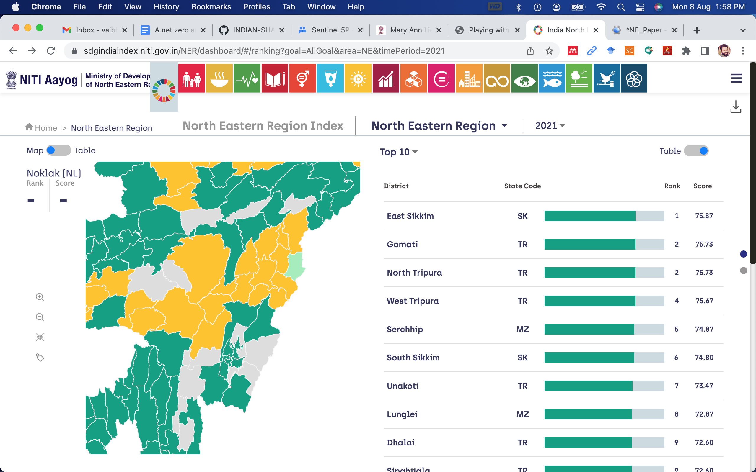
I went through the district level data and found one missing district in the North Eastern state of Nagaland. As highlighted in the screenshot from NITI Aayog Dashboard on SDG, this district of Noklak has been created from the adjacent district of Tuensang.
If you can check and update the same on github.
Regards,
Vaibhav
To view this discussion on the web visit https://groups.google.com/d/msgid/datameet/CAMgvHC6FcNG5QDGYKhdMyxSxzK%3D_G_y0CmVd4oHgvg47swf4kw%40mail.gmail.com.
Akula Guru Datta
Aug 8, 2022, 10:10:13 AM8/8/22
to data...@googlegroups.com
Hi
Vaibhav,
I updated this Indian districts file 13 days back. Download the new one, it has that district.
To view this discussion on the web visit https://groups.google.com/d/msgid/datameet/CA%2BU9tP8YtasBZ2OG5mFwbOqoa1WyHK9UnxkXdQLtYYwQ0CD0cA%40mail.gmail.com.

Cara Foss Arellano
Aug 21, 2022, 10:56:49 PM8/21/22
to data...@googlegroups.com
Thank you!!!
--
Datameet is a community of Data Science enthusiasts in India. Know more about us by visiting http://datameet.org
---
You received this message because you are subscribed to the Google Groups "datameet" group.
To unsubscribe from this group and stop receiving emails from it, send an email to datameet+u...@googlegroups.com.
To view this discussion on the web visit https://groups.google.com/d/msgid/datameet/c586dac0-8513-4668-9eeb-d6181b7f1fc2n%40googlegroups.com.

Rahul Dhiman
Nov 8, 2022, 12:08:08 AM11/8/22
to datameet
Hello Akula. First of all thankyou for taking time to create this shape file and making our lives easier. Please can anybody tell me how to download the data, as when I am clicking download. It is just opening a long list of lat and longs of feature polygon. How I can download the shape file?
Regards,
Rahul

Devdatta Tengshe
Nov 8, 2022, 12:55:23 AM11/8/22
to data...@googlegroups.com
Rahul,
This data is in GeoJSON format, and not shapefile.
Once you download the data in GeoJSON format, you can then convert it to a Shapefile using a GIS tool like QGIS, or one of many online convertors.
Regards,
Devdatta
To view this discussion on the web visit https://groups.google.com/d/msgid/datameet/ba012d6f-1686-430f-b440-417ec03e51cbn%40googlegroups.com.
Nikhil VJ
Nov 11, 2022, 2:10:13 AM11/11/22
to data...@googlegroups.com
Hi Rahul,
Once you see the:
It is just opening a long list of lat and longs of feature polygon
.. press Ctrl+S on your keyboard.
Save it to your computer. ensure that the file has extension as ".geojson".
That is the shapefile. There's various formats - this one is .geojson. Devdatta mentioned another format which would be the .shp etc. All are equally usable, all depends on your next step.
Open QGIS or ArcGIS and drag-drop this in, you'll see it on map.
Or, go on https://geojson.io and drag-drop it there, you'll see it on map.
To view this discussion on the web visit https://groups.google.com/d/msgid/datameet/CAOQOUMtDEDaTWMDPLbyZ8BQERRRCRUjUwQ_nU8vOMCmQCS6uFw%40mail.gmail.com.

uday...@gmail.com
Apr 30, 2023, 12:44:51 PM4/30/23
to datameet
Hello all,
QGIS throws error when i tried to open these files. Even geojson.io is throwing up an error - "Invalid JSON file: SyntaxError: JSON.parse: unexpected character at line 8 column 1 of the JSON data". I am new to GIS and intersted to learn. Kindly look into this, as you have time. Any help is highly appreciated.
Uday.
Nikhil VJ
May 1, 2023, 2:01:24 AM5/1/23
to data...@googlegroups.com
Hi Uday,
I just reproduced the steps and successfully loaded it to QGIS. no error in the file.
Please go through all the explanations given in the thread. They've been VERY basic.
If you're still not able to do it correctly, then you need to give some exact details so that someone can help you. Like :
- what is size of saved file - if it's not around 39mb (some computers calculate bytes differently (1024 vs 1000) so bit difference may be there but explainable) - then you don't have the actual data file and you've saved something else and are on wrong track
- what is extension of saved file - if it's not .geojson then you're on wrong track.
- open the file in a text editor like VSCode and share the content up till : " line 8 column 1" where you're getting the error. And if it's not looking like:
{"type":"FeatureCollection", "features": [
{"type":"Feature","geometry":{"type":"Polygon","coordinates":[[[71.2702884145729,23 ....
{"type":"Feature","geometry":{"type":"Polygon","coordinates":[[[71.2702884145729,23 ....
... then you're on wrong track.
Sometimes it's just a messed-up download due to network issues and simply repeating the download again solves it.
Do try looking up online for what the .geojson format looks like, compare etc to catch out any obvious mistakes.
If you're convinced that you're following everything properly and still getting it wrong, then make a screen recording, upload to youtube and share the link so you can show exact process and get feedback.
To view this discussion on the web visit https://groups.google.com/d/msgid/datameet/7e8c7dd8-a69c-494c-81e3-30a6a92c8cf9n%40googlegroups.com.
Uday Bhaskar Reddy
May 2, 2023, 1:46:17 PM5/2/23
to data...@googlegroups.com
Hello Nikil,
I am very sorry for the delay in replying to your email. Appreciate and thank you for finding the time to test the working of the file. I will follow your instructions and try it again.
Regards,
Uday.
You received this message because you are subscribed to a topic in the Google Groups "datameet" group.
To unsubscribe from this topic, visit https://groups.google.com/d/topic/datameet/4kuQecxfEv8/unsubscribe.
To unsubscribe from this group and all its topics, send an email to datameet+u...@googlegroups.com.
To view this discussion on the web visit https://groups.google.com/d/msgid/datameet/CAH7jeuM4EZ89uNs3v9pY%2Bq9NNY%3DFyqfSfYcNKDCLfD4TeQ8mDA%40mail.gmail.com.

Curran Kelleher
May 3, 2023, 7:43:49 PM5/3/23
to datameet
I've simplified the geometries to a smaller file (from 30MB to less than 1MB) using MapShaper and made them available here: https://gist.github.com/curran/49fa25fc44c84fcbebb51e60946145a4
Regards,
Curran
Reply all
Reply to author
Forward
0 new messages