Need temperature data district wise
123 views
Skip to first unread message

Jayshree Dutta
Jul 7, 2022, 3:23:27 PM7/7/22
to data...@googlegroups.com
Hello, I'm doing my Ph.D in Chennai and currently visiting researcher in Austria. I need India's district wise data on Temperature (avg, or min -max), humidity, wind velocity and total sun shine hours. Can anyone help me getting these datasets? Atleast any of them? Anytime after 2015 sound be fine, and of course more recent the better!
With regards
Jay

chris mathen
Jul 7, 2022, 10:30:33 PM7/7/22
to data...@googlegroups.com
Gridded rainfall and temperature data are available on this website.
Regards,
Christopher Kuruvilla Mathen
--
Datameet is a community of Data Science enthusiasts in India. Know more about us by visiting http://datameet.org
---
You received this message because you are subscribed to the Google Groups "datameet" group.
To unsubscribe from this group and stop receiving emails from it, send an email to datameet+u...@googlegroups.com.
To view this discussion on the web visit https://groups.google.com/d/msgid/datameet/CAFFWLbCs3vAtVmdp1u6yfjhp3Rwvod0N6axt5_m_o-ONWWUJuQ%40mail.gmail.com.

Dammalapati Sai Krishna
Jul 7, 2022, 10:30:48 PM7/7/22
to data...@googlegroups.com
The method to acquire this data and to aggregate it at district levels can be taken from here: https://github.com/d-saikrishna/GIS_RemoteSensing/blob/master/Covid_Env/Data%20Collection%20and%20Pre-Processing.ipynb
Let me know if you need more help.
Hello, I'm doing my Ph.D in Chennai and currently visiting researcher in Austria. I need India's district wise data on Temperature (avg, or min -max), humidity, wind velocity and total sun shine hours. Can anyone help me getting these datasets? Atleast any of them? Anytime after 2015 sound be fine, and of course more recent the better!With regardsJay
--

Nikhil VJ
Jul 13, 2022, 3:24:13 AM7/13/22
to datameet
Hi,
(replying to this thread with a changed subject line)
I searched on net for how to extract the imdb gridded data (Sai Kirshna thanks for ur program too)
And I found this video: https://www.youtube.com/watch?v=40Dvj6MwGTs by OpenGeoLab channel on youtube (done some pretty good training work in GIS!)
Mentions: "imdblib" python package.. and it looks like that one takes care of a lot of the complexity for us! Big thanks to Saswati Nandi who authored it.
With a bit of looking up I was able to bring the data out to a simple flat table format that we all know and love.
Sharing the code of a sample extraction here:
I took out some data for nearby Pune, and have done a quick viz in this google doc:
https://docs.google.com/spreadsheets/d/13j3kMvGdr52_dX-4nG9YDFCu3ZO_sYadFmYeiZJVgWo/edit?usp=sharing
Observations:
1. There is a lot of junk data in there : for 1950s yrs that I saw it was over 60%. Fixed values like -999 are filled in where there wasn't any reading for that particular place and date - probably because the data system being used couldn't work with nulls. So it's important to get rid of the junk data points before moving forward.
2. If I 7z-zipped the flat table csv after removing the junk data, and whadyaknow, the result is smaller. (tip for folks managing this department in IMD. Also, check out HDF5 format)
3. There's 3 data items: Max temp, min temp, rainfall.
4. Temp data is resolved to .5 lat-long points and available from 1950. Rain data is resolved to .25 lat-long points and available from 1901.
Next steps:
As usual I'm going to setup a week-long script (going year by year only, with plenty of pauses so that it doesn't overload the IMD site, mind!), extract it all and load it up into a Postgresql DB / API etc for accessing.
Would anyone out there like to collaborate on a visualization?
We have data that is in point lat-long form, and is temporal with date-wise resolution.
So, map-based combined with time series and/or animation would be good.
To view this discussion on the web visit https://groups.google.com/d/msgid/datameet/BDDF6844-ECF4-4B08-A048-BAC7F1F549AC%40gmail.com.
Dammalapati Sai Krishna
Jul 13, 2022, 3:43:25 AM7/13/22
to data...@googlegroups.com
Hi Nikhil, glad that my program is of some help.
If the animation you’re thinking is somewhat like this, I can collaborate with you! Let me know :)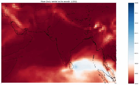
Sent from my iPhone
On 13-Jul-2022, at 12:54 PM, Nikhil VJ <nikh...@gmail.com> wrote:
To view this discussion on the web visit https://groups.google.com/d/msgid/datameet/CAH7jeuNH8w9tTSFofcvrzibAFTLJM2VBz64ELk1tPxzgn_F5Yw%40mail.gmail.com.
Nikhil VJ
Jul 15, 2022, 1:48:08 AM7/15/22
to datameet
Hi,
PostGresSQL DB loading of IMD's gridded weather data is complete.
I've put the import script with detailed steps and some python jupyter notebooks (the kind where you see both code and output at the same place) with sample code for working with this DB in this repo:
Consider it as a toolkit: It should help folks with just minimal exposure to python (or just how to run things) to get setup at their end with this data, and they can play around with it in many ways.
Will start a closed email thread with the folks who wrote back for collab. (more can write in and I'll add you, or post an issue in the above repo)
Thanks!
To view this discussion on the web visit https://groups.google.com/d/msgid/datameet/6371520F-2488-4FF3-97A0-3DE971E09012%40gmail.com.
Reply all
Reply to author
Forward
0 new messages