BhuNaksha: source of cadastral maps
3,297 views
Skip to first unread message

Sharad Lele
Dec 13, 2019, 8:39:02 AM12/13/19
to datameet
Dear All,
I have discovered a source of cadastral maps for several states. This is mostly under the BhuNaksha initiative of NIC. They seem to have created separate websites for each state. Don't know for how many. I have found:
Madhya Pradesh: http://www.mpbhuabhilekh.nic.in/
Chhattisgarh: https://bhunaksha.cg.nic.in/#home-pane (DOES NOT WORK RIGHT NOW)
The BhuNaksha websites have a common format: you can choose district, taluka and village, and then the village cadastral map shows up (its in png format). You can click on a plot/parcel, and it will show the details of that plot: area, owner name, etc. You can generate pdf report for that parcel.
Maharashtra version had added ability to show you the cadastral map in geo-rectified mode on top of a google-earth-like satellite image--quite useful.
CATCH: a) the names of district, taluka, village etc are IN THE STATE SCRIPT: so devanagari for MP & Maha & CG, but Odiya for Odisha. So if you don't read that script--you are sunk
b) in most states (except Maharashtra!), it is not enough to know the district, taluka and village name. Within a taluka, you have know Revenue Inspector and then something called 'halka', and then choose from the villages within that halka. If you don't know this (RI and halka), you have to do brute force: search in each halka in each RI! (typical sarkari rubbish: not wanting common people to actually use the website!).
Karnataka seems to have its own initiative: https://www.landrecords.karnataka.gov.in/service3/
Here, you can actually download pdfs of each cadastral map, and in some cases, even the KML! And searching for the village is district, taluka and then village.
Hope this helps.
I am sure there are more such websites for other states. Please look up and share.
Sharad

Naraina Damle
Dec 13, 2019, 1:01:47 PM12/13/19
to datameet
Interesting
Sharad Lele
Dec 14, 2019, 12:46:35 AM12/14/19
to datameet
More Information on Bhu Naksha initative is avaliable at:
(Thanks to Naveen Francis for sharing this link)

Prabhakar Rajagopal
Dec 20, 2019, 10:46:04 AM12/20/19
to data...@googlegroups.com
Dear Sharad,
Have you looked at Bharatmaps...
They have all the census villages all marked up and much more.
They have all the SOI layers on the map as well.
Good to visualize.
Prabhakar
--
Datameet is a community of Data Science enthusiasts in India. Know more about us by visiting http://datameet.org
---
You received this message because you are subscribed to the Google Groups "datameet" group.
To unsubscribe from this group and stop receiving emails from it, send an email to datameet+u...@googlegroups.com.
To view this discussion on the web visit https://groups.google.com/d/msgid/datameet/949238e4-1f34-49b3-a8c0-08bf30a5979a%40googlegroups.com.

Sumantra Misra
Dec 23, 2019, 3:57:45 AM12/23/19
to data...@googlegroups.com
This was extremely helpful. Thank you so much .. !!
--
Datameet is a community of Data Science enthusiasts in India. Know more about us by visiting http://datameet.org
---
You received this message because you are subscribed to the Google Groups "datameet" group.
To unsubscribe from this group and stop receiving emails from it, send an email to datameet+u...@googlegroups.com.
To view this discussion on the web visit https://groups.google.com/d/msgid/datameet/7fcd0bd1-40a3-4709-adee-7c681e409963%40googlegroups.com.
Sharad Lele (शरच्चंद्र लेले)
Dec 23, 2019, 6:37:07 AM12/23/19
to Prabhakar Rajagopal, data...@googlegroups.com
Dear Prabhakar:
Thanks for the link. I looked it up. It is rather awkward to use, and I could not see SOI layers. Most important, there is no cadastral information, only village boundaries. And of course, like in the other cases, the boundary is not downloadable.
Best,
Sharad
You received this message because you are subscribed to a topic in the Google Groups "datameet" group.
To unsubscribe from this topic, visit https://groups.google.com/d/topic/datameet/7t8B-rbD7X4/unsubscribe.
To unsubscribe from this group and all its topics, send an email to datameet+u...@googlegroups.com.
To view this discussion on the web visit https://groups.google.com/d/msgid/datameet/CABzdB7Y24awBbajvKExXnjD%2BC0yVQeVW1D_03ijJNq2KKL2X%2BQ%40mail.gmail.com.

kalthi sandeep
Jan 10, 2020, 10:23:28 AM1/10/20
to data...@googlegroups.com
Sir
I Kalthi Sandeep
I need cadastral maps of Andhra Pradesh state
Please help me for finding maps
With Regards
Kalthi Sandeep
--
Datameet is a community of Data Science enthusiasts in India. Know more about us by visiting http://datameet.org
---
You received this message because you are subscribed to the Google Groups "datameet" group.
To unsubscribe from this group and stop receiving emails from it, send an email to datameet+u...@googlegroups.com.
To view this discussion on the web visit https://groups.google.com/d/msgid/datameet/7fcd0bd1-40a3-4709-adee-7c681e409963%40googlegroups.com.

Natasha kalra
Jan 13, 2020, 9:11:40 PM1/13/20
to data...@googlegroups.com
hi
trying to download for Karnataka
Once I download KML file what to do next?????
--
Sharad Lele
Apr 25, 2020, 3:56:28 AM4/25/20
to datameet
Dear All,
A followup question addressed to everyone on the DATAMEET group:
Can someone write code to help download a large number of cadastral maps from a Bhunaksha website (in our case Chhattisgarh)? As you know, the website /portal is awkwardly organized: not only are the maps in png format (which is okay) but they don't have individual file names, and one has to access each village separately by choosing it from a list within a taluka (and within that some Revenue Inspector category).
Can someone write code to download and tag a bunch of maps automatically? Say for one whole taluka?
Sharad
On Friday, 13 December 2019 19:09:02 UTC+5:30, Sharad Lele wrote:

Dilawar Singh
Apr 26, 2020, 6:00:35 AM4/26/20
to datameet
Its quite possible. I've used python+selenium to automate browser for a horribly designed website. You can tweak it for your usage: https://github.com/dilawar/GreenWatchData
best,
Dilawar
Sharad Lele (शरच्चंद्र लेले)
Apr 26, 2020, 9:07:49 AM4/26/20
to data...@googlegroups.com, Dilawar Singh
Dear Dilawar:
Many thanks for sharing this. Unfortunately, I am a complete ignoramus when it comes to Python, selenium or even accessing stuff from GitHub :-[
Is there any way that you (or anyone else) can help? (Sorry,
probably asking too much here!)
The site is http://bhunaksha.cg.nic.in/
(It appears to have gone down today, should be up tomorrow or
so).
--
Datameet is a community of Data Science enthusiasts in India. Know more about us by visiting http://datameet.org
---
You received this message because you are subscribed to a topic in the Google Groups "datameet" group.
To unsubscribe from this topic, visit https://groups.google.com/d/topic/datameet/7t8B-rbD7X4/unsubscribe.
To unsubscribe from this group and all its topics, send an email to datameet+u...@googlegroups.com.
To view this discussion on the web visit https://groups.google.com/d/msgid/datameet/8ba4688b-25fd-4d01-a4da-5adc31da1459%40googlegroups.com.
Dilawar Singh
Apr 26, 2020, 2:46:25 PM4/26/20
to datameet
Hello Sharad
Here you go: https://gitlab.com/dilawar/bhunaksha/-/tree/master
Currently only district images of MP are downloaded and added to repository above. You can browse them (link above) or download as a zip file from here: https://gitlab.com/dilawar/bhunaksha/-/archive/v2020.04.26/bhunaksha-v2020.04.26.zip .
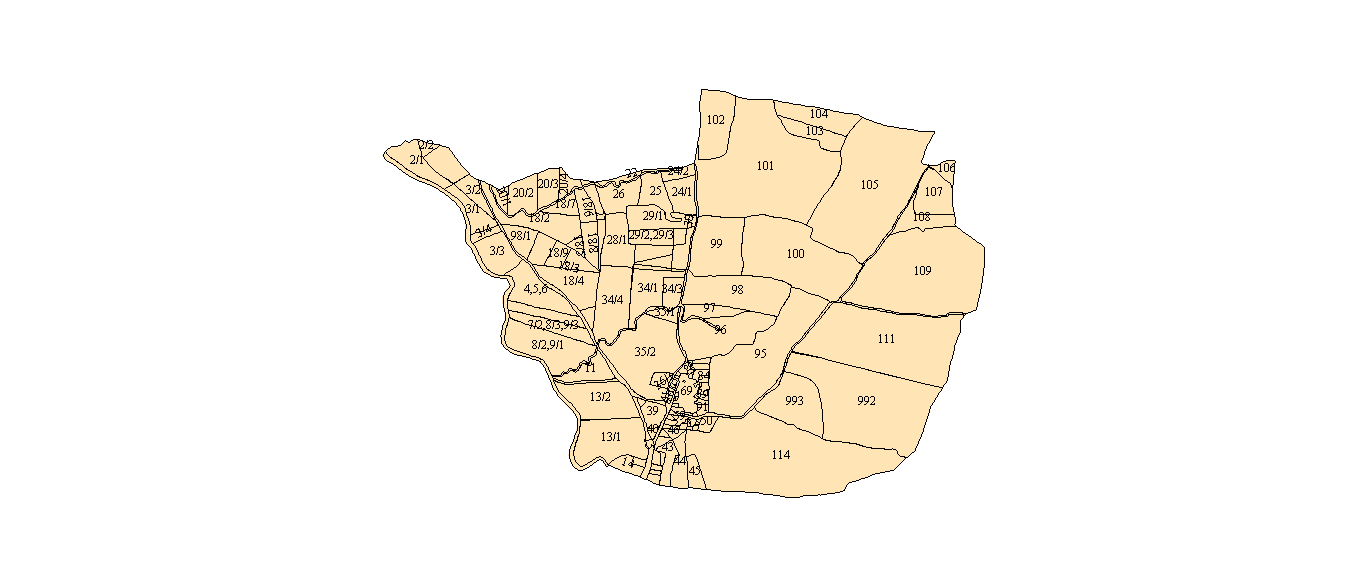
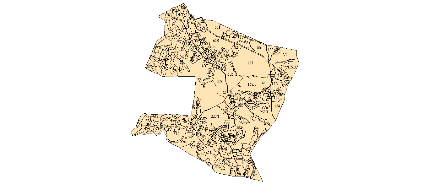
Couple of samples are attached with this email. I am not sure what exactly is needed. If you can send couple of screenshots of what exactly is needed, I can tweak this script a bit over next weekend.
Note that canvas size is small since I was using a laptop.
PS: The script is released under GNU GPLv3.
best,
Dilawar
To unsubscribe from this group and all its topics, send an email to data...@googlegroups.com.
Dilawar Singh
May 31, 2020, 10:37:37 AM5/31/20
to datameet
The updated script is available publicly on Gitlab https://gitlab.com/snippets/1982028 . It has to be tweaked for different states.
best,
Dilawar

rajesh...@gmail.com
Nov 10, 2020, 6:02:56 AM11/10/20
to datameet
Dear All,
Village No
Ara
Asri
Atna
Baheya
Bakar
Bamhni
Bana
Bandabir
Bansa
Baram,
Barumda
Barwadag
Bintuka
Boch Kam Kocha
Bongaibera
Burudih
Chamardag
Chatra
Datam
daud nagar
Dere
Deuli
Dugdha
Dulmi
Goradih
Gunda
Gunddih
Guridih
Hapatbera
Haratu
Harup
Hatia
Heben
Heremuli
Hesalang
Heslabera
Holong
Ichadih
jagannath pur
Janum
Jarakel
Jidu
Jonha
kadru
Karkata
Kashidih
Kebetang
Kenduadih
Khatjori
Khudilong
Konaroan
Kulsud
Kuri
Kusputul
Lupungdih
Magistrate colony
mahara toli
Mahilong
Mahtokulhi
M-Colony
Muri
Muru
Murugdih
Nawadih
north office para
old A.G colony
Pahar Singh
Pangur
Pitki
Rajadera
Russial Hostel Colony
Samdega
Saryatar
sattelite colony
Silwai
Sima
Sirkadih
Sitadih
Site 5
Soe
sopa
Tankocha
Tati
Tiraldih
Toneya
Torian
Tulin
Turuyu
Udhatanr
Uhupiri
Uria
Kindly help me to get the listed village cadastral maps.
Village No
Ara
Asri
Atna
Baheya
Bakar
Bamhni
Bana
Bandabir
Bansa
Baram,
Barumda
Barwadag
Bintuka
Boch Kam Kocha
Bongaibera
Burudih
Chamardag
Chatra
Datam
daud nagar
Dere
Deuli
Dugdha
Dulmi
Goradih
Gunda
Gunddih
Guridih
Hapatbera
Haratu
Harup
Hatia
Heben
Heremuli
Hesalang
Heslabera
Holong
Ichadih
jagannath pur
Janum
Jarakel
Jidu
Jonha
kadru
Karkata
Kashidih
Kebetang
Kenduadih
Khatjori
Khudilong
Konaroan
Kulsud
Kuri
Kusputul
Lupungdih
Magistrate colony
mahara toli
Mahilong
Mahtokulhi
M-Colony
Muri
Muru
Murugdih
Nawadih
north office para
old A.G colony
Pahar Singh
Pangur
Pitki
Rajadera
Russial Hostel Colony
Samdega
Saryatar
sattelite colony
Silwai
Sima
Sirkadih
Sitadih
Site 5
Soe
sopa
Tankocha
Tati
Tiraldih
Toneya
Torian
Tulin
Turuyu
Udhatanr
Uhupiri
Uria
Regards
rajesh kumar
Nov 10, 2020, 6:50:35 AM11/10/20
to data...@googlegroups.com
Dear Dilwar ji,
Kindly help me to get the listed villate mouza data.
For District - Jharkhand, District - Ranchi, Lohardaga
--
Datameet is a community of Data Science enthusiasts in India. Know more about us by visiting http://datameet.org
---
You received this message because you are subscribed to the Google Groups "datameet" group.
To unsubscribe from this group and stop receiving emails from it, send an email to datameet+u...@googlegroups.com.
To view this discussion on the web visit https://groups.google.com/d/msgid/datameet/8ba4688b-25fd-4d01-a4da-5adc31da1459%40googlegroups.com.

SWAPNESWAR DEHURY
Mar 8, 2022, 2:50:32 AM3/8/22
to datameet
Please share Jharkhand viilage boundary as per 2011 census
Reply all
Reply to author
Forward
0 new messages