all geojson data is not diplaying
248 views
Skip to first unread message

mka...@tamimicg.com
Mar 14, 2020, 6:44:40 AM3/14/20
to cesium-dev
Dear Sir,
I am displaying geojson which has around 897 records it displays data but not all. out of 897, it displays around 100 records
is there any limitations or license I don't understand because all is the same data from a single geojson file
I am using Windows operating system. chrome as browser and reactJS for development
here is my code
var dataSource = this.state.Viewer.dataSources.add(this.state.Cesium.GeoJsonDataSource.load('data/adu_governorate..geojson', {
stroke: this.state.Cesium.Color.HOTPINK,
fill: this.state.Cesium.Color.PINK.withAlpha(0.5),
strokeWidth: 3,
clampToGround: true
}));
this.state.Viewer.dataSources.add(dataSource);
here is how it displays

Thank you
Mohammed Kabeer

Omar Shehata
Mar 16, 2020, 3:43:56 PM3/16/20
to cesium-dev
There shouldn't be any limitations here. Would you be able to share this GeoJSON with me so I can take a look?
You can upload it on Cesium ion and post a link to your Sandcastle example here.
Mohammad Kabeer
Mar 17, 2020, 2:50:22 AM3/17/20
to cesiu...@googlegroups.com, Faisal Al-Tamimi, Mohammad Kabeer
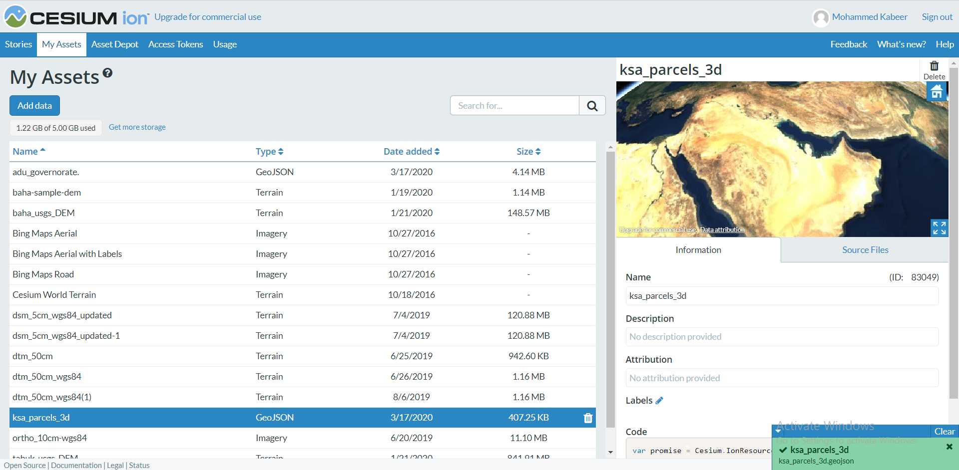
sure here I am attaching 2 files one for 2D data (145) records.
adu_governorate..geojson
the other one is 3D data (891) records
ksa_parcels_3d.geojson
Thank you
Mohammed Kabeer
--
You received this message because you are subscribed to a topic in the Google Groups "cesium-dev" group.
To unsubscribe from this topic, visit https://groups.google.com/d/topic/cesium-dev/5A2mfG1dq60/unsubscribe.
To unsubscribe from this group and all its topics, send an email to cesium-dev+...@googlegroups.com.
To view this discussion on the web visit https://groups.google.com/d/msgid/cesium-dev/3539bbbb-418d-4562-9693-7e3d0e1d8dd2%40googlegroups.com.
Mohammad Kabeer
Mar 17, 2020, 9:31:21 AM3/17/20
to cesiu...@googlegroups.com, Faisal Al-Tamimi, Mohammad Kabeer
Dear Mr.Omar
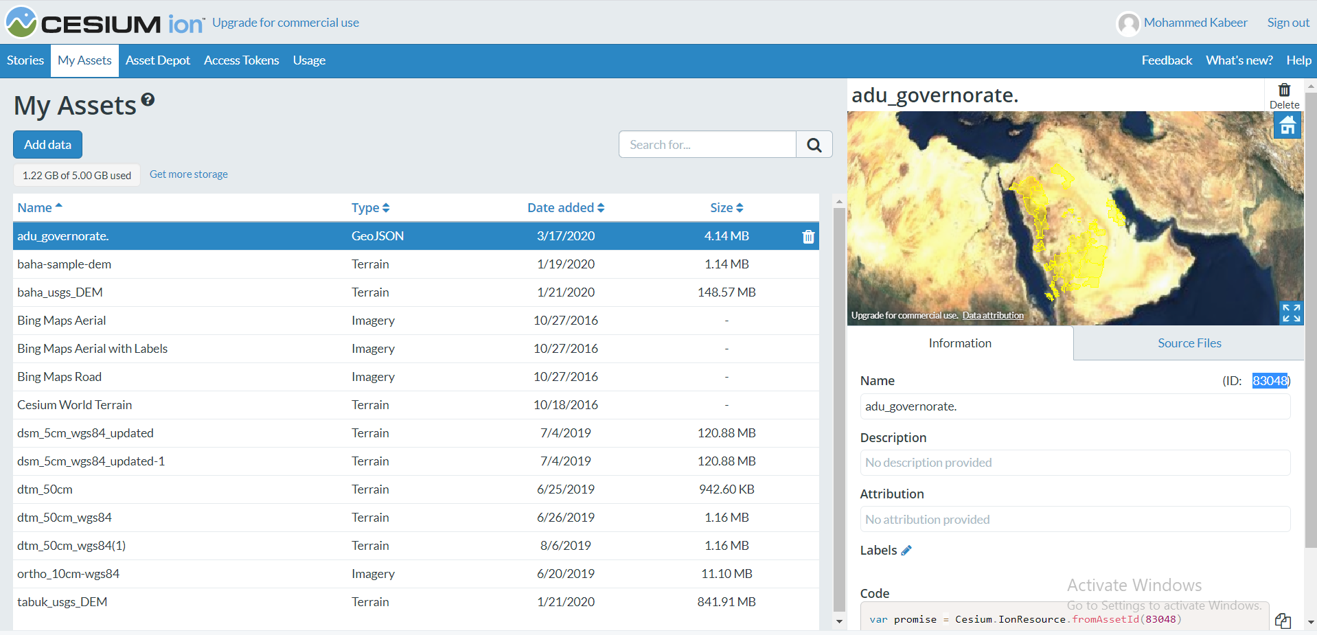
here I uploaded in ion server also, please look at it
Thank you
Mohammed Kabeer
On Mon, Mar 16, 2020 at 10:44 PM Omar Shehata <omar.same...@gmail.com> wrote:

Scott Reynolds
Mar 17, 2020, 9:05:10 PM3/17/20
to cesium-dev
I loaded both of the supplied into QGIS. QGIS reported that both files contain 50 features. I had no problem displaying the adu_governorate data in Sandcastle. One of the features, Farasan, consists of 61 or 62 islands.
Cesium fails to load the ksa_parcels_3d data because of the CRS being urn:ogc:def:crs:EPSG::4327. The EPSG website identifies it as being deprecated and 3D. That CRS is not supported by Cesium and results in a runtime error "Unknown crs name: urn:ogc:def:crs:EPSG::4327".
Scott
Mohammad Kabeer
Mar 19, 2020, 6:55:31 AM3/19/20
to cesiu...@googlegroups.com, Mohammad Kabeer, Faisal Al-Tamimi
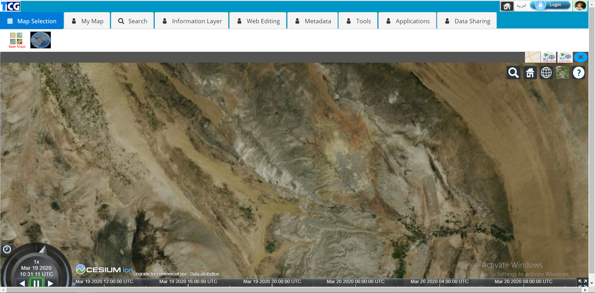
yes I did export the file using QGIS and displaying all records but still, there is one problem why tiny part of tiles are missing 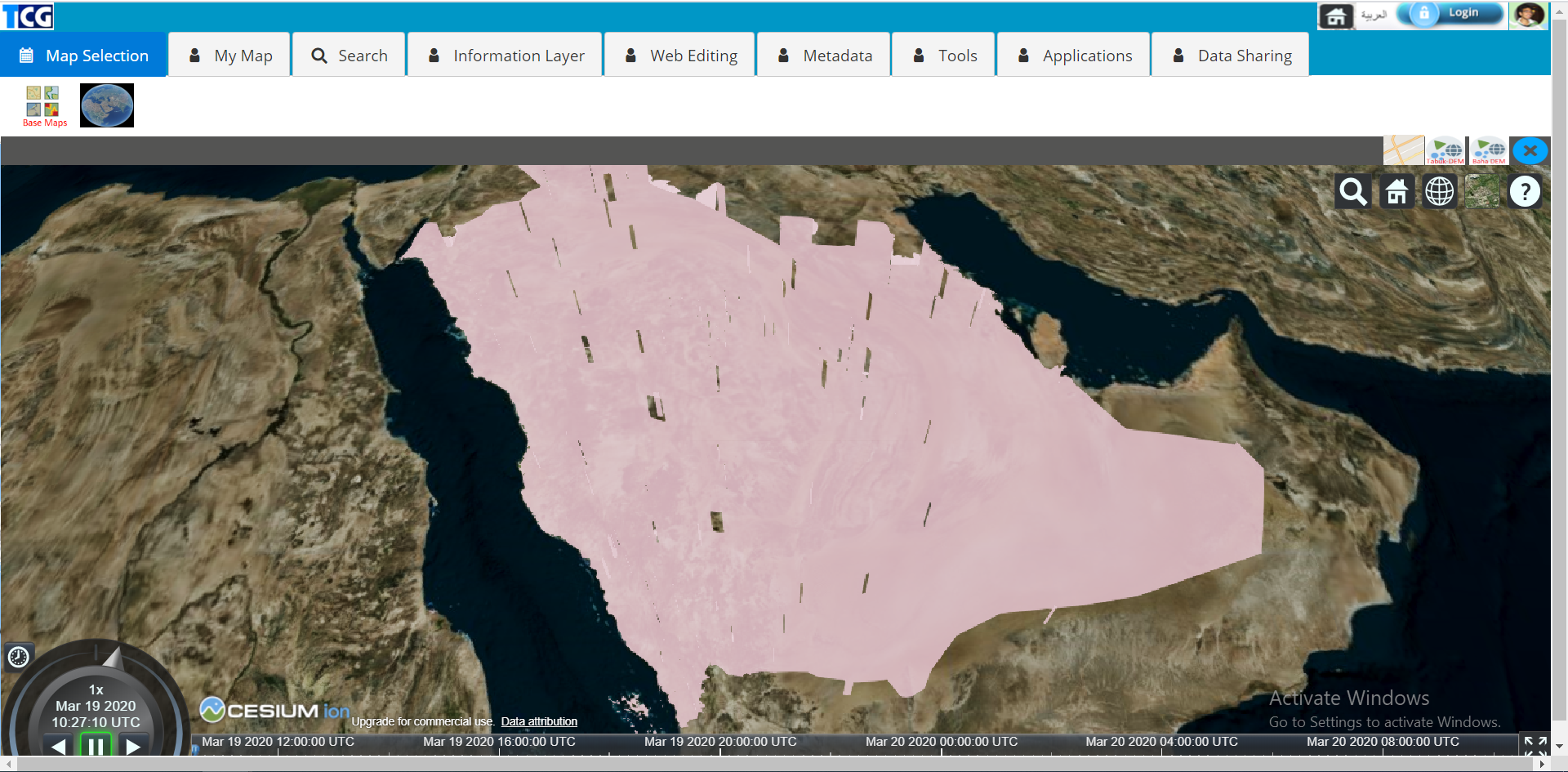
please see the picture
Thank You
Mohammed Kabeer
--
You received this message because you are subscribed to a topic in the Google Groups "cesium-dev" group.
To unsubscribe from this topic, visit https://groups.google.com/d/topic/cesium-dev/5A2mfG1dq60/unsubscribe.
To unsubscribe from this group and all its topics, send an email to cesium-dev+...@googlegroups.com.
To view this discussion on the web visit https://groups.google.com/d/msgid/cesium-dev/11c745cc-ba6b-4483-8bc7-c4b2c6e5da9e%40googlegroups.com.
Mohammad Kabeer
Mar 19, 2020, 6:58:59 AM3/19/20
to cesiu...@googlegroups.com, Mohammad Kabeer, Faisal Al-Tamimi
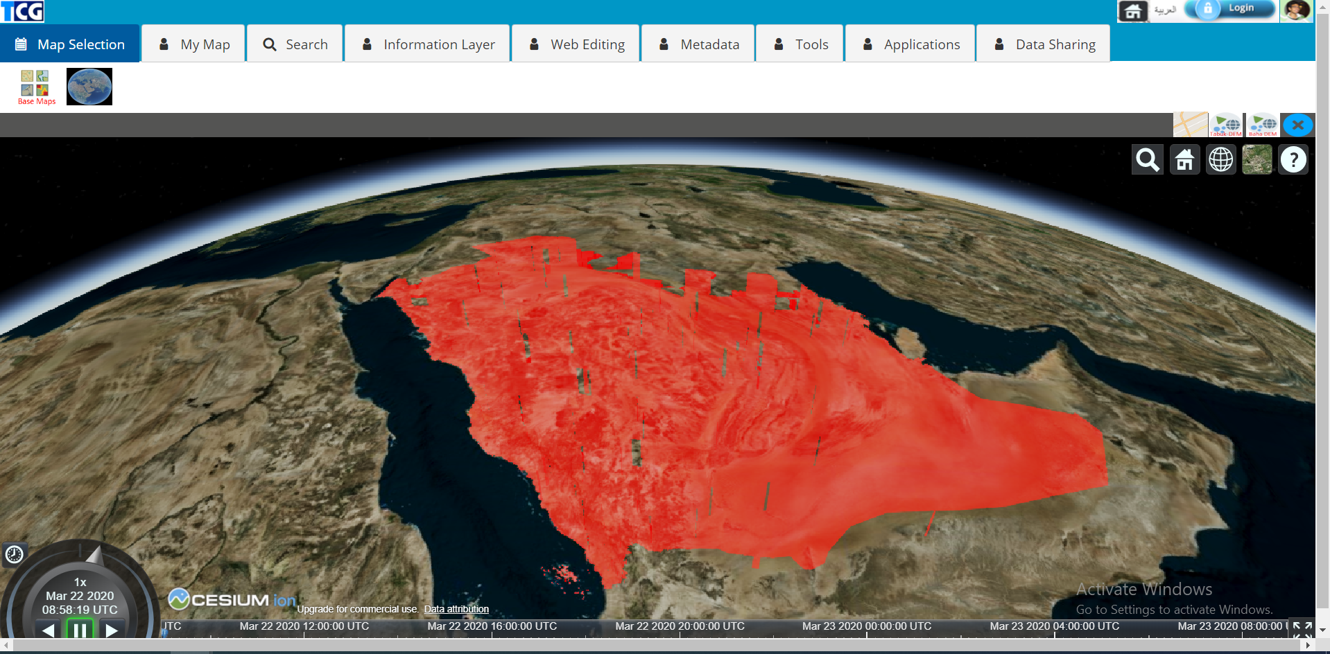
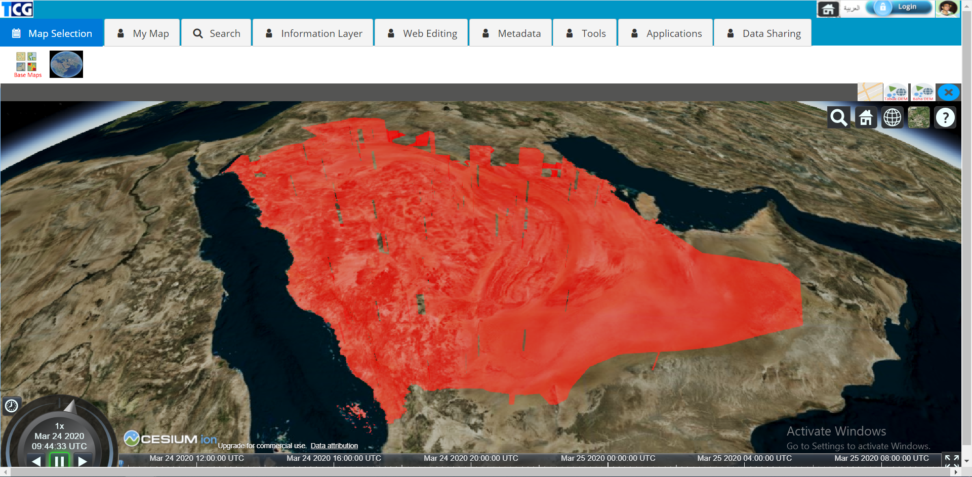
Dear Sir,
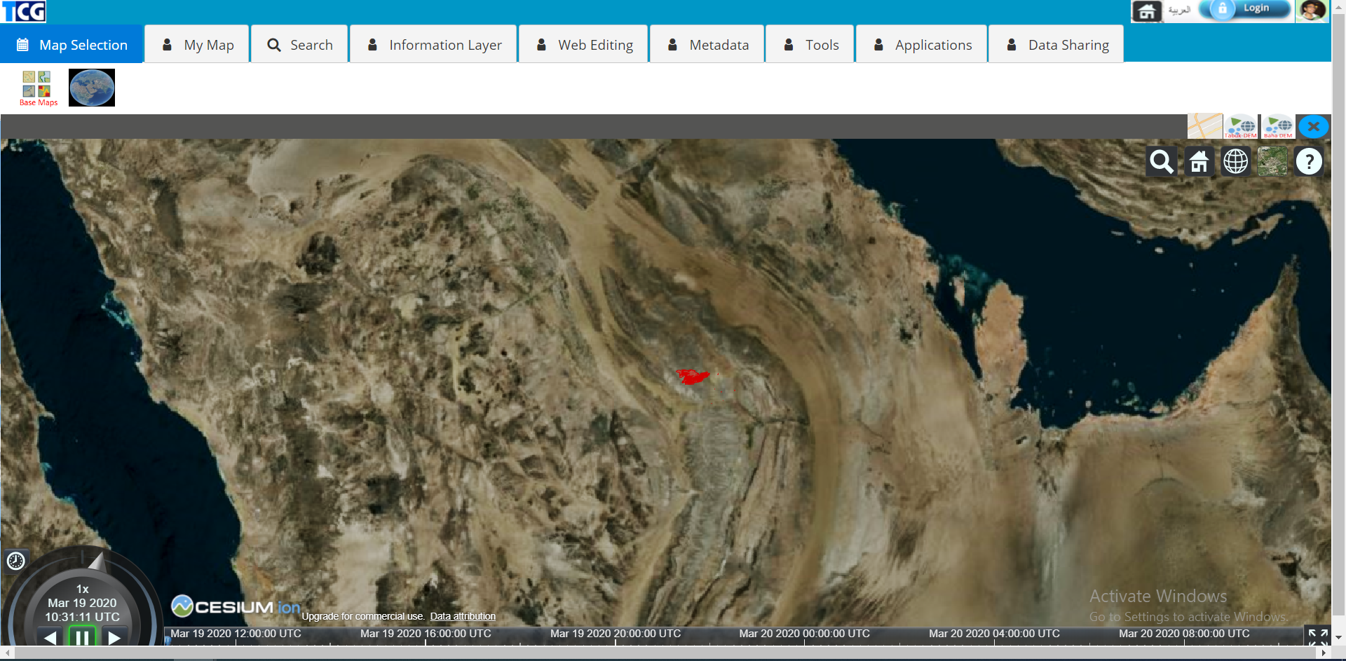
another 3D file (ryd_parcel_3d) exported from QGIS with "urn:ogc:def:crs:OGC:1.3:CRS84" referencing system
it shows data for zoom levels but when I zoom more the data disappears
when I zoom more disappears
here I am attaching snapshots and exported geojson file please try this file your side
Thank you
Mohammed Kabeer
On Wed, Mar 18, 2020 at 4:05 AM Scott Reynolds <sc...@stk.com> wrote:
--
You received this message because you are subscribed to a topic in the Google Groups "cesium-dev" group.
To unsubscribe from this topic, visit https://groups.google.com/d/topic/cesium-dev/5A2mfG1dq60/unsubscribe.
To unsubscribe from this group and all its topics, send an email to cesium-dev+...@googlegroups.com.
To view this discussion on the web visit https://groups.google.com/d/msgid/cesium-dev/11c745cc-ba6b-4483-8bc7-c4b2c6e5da9e%40googlegroups.com.
Scott Reynolds
Mar 19, 2020, 8:43:11 PM3/19/20
to cesium-dev
This looks like the problem described here. Modifying the polygons to use the geodesic arc type looks like it fixes the problem.
var viewer = new Cesium.Viewer('cesiumContainer');var dataSource = Cesium.GeoJsonDataSource.load('../../SampleData/adu_governorate_qgis_SOME.geojson', { clampToGround: true, stroke: Cesium.Color.HOTPINK, fill: Cesium.Color.PINK.withAlpha(0.5), strokeWidth: 3 });dataSource.then(function(data) { // Change the arcType to GEODESIC, which is what it was in CesiumJS 1.53. for (var i = 0; i < data.entities.values.length; i++) { var entity = data.entities.values[i]; if (Cesium.defined(entity.polygon)) { entity.polygon.arcType = Cesium.ArcType.GEODESIC; } } viewer.dataSources.add(dataSource);});
Please see if that works for you.
Scott
Mohammad Kabeer
Mar 22, 2020, 4:53:46 AM3/22/20
to cesiu...@googlegroups.com, Mohammad Kabeer, Faisal Al-Tamimi
Dear Sir,
I will check this function and will let you know
how about the 3D file can you please check that (ryd_parcel_3d)
Thank you
Mohammed Kabeer
--
You received this message because you are subscribed to a topic in the Google Groups "cesium-dev" group.
To unsubscribe from this topic, visit https://groups.google.com/d/topic/cesium-dev/5A2mfG1dq60/unsubscribe.
To unsubscribe from this group and all its topics, send an email to cesium-dev+...@googlegroups.com.
To view this discussion on the web visit https://groups.google.com/d/msgid/cesium-dev/88db6ebd-8045-49d2-ab3f-627453c72687%40googlegroups.com.
Scott Reynolds
Mar 22, 2020, 8:33:54 PM3/22/20
to cesium-dev
The ryd_parcel_3d file looks good also.
Scott
Mohammad Kabeer
Mar 23, 2020, 4:27:32 AM3/23/20
to cesiu...@googlegroups.com, Faisal Al-Tamimi, Mohammad Kabeer
Dear Scott,
I tried the following GEODESIC converting function but still, it is missing tiles
and I tried the 3D file also with
GEODESIC function and without but still, it's not appearing when I zoom more
please check the 3D file
here is the function what I am using
var dataSource2 = this.state.Viewer.dataSources.add(this.state.Cesium.GeoJsonDataSource.load('data/adu_governorate_qgis.geojson', {
stroke: this.state.Cesium.Color.RED,
fill: this.state.Cesium.Color.RED.withAlpha(0.5),
strokeWidth: 10,
clampToGround: true
}));
dataSource2.then(function(data) {
// Change the arcType to GEODESIC, which is what it was in CesiumJS 1.53.
for (var i = 0; i < data.entities.values.length; i++) {
var entity = data.entities.values[i];
if (this.state.Cesium.defined(entity.polygon)) {
entity.polygon.arcType = this.state.Cesium.ArcType.GEODESIC;
}
}
this.state.Viewer.dataSources.add(dataSource2);
});
Thank you
Mohammed Kabeer
On Mon, Mar 23, 2020 at 3:34 AM Scott Reynolds <sc...@stk.com> wrote:
The ryd_parcel_3d file looks good also.Scott
--
You received this message because you are subscribed to a topic in the Google Groups "cesium-dev" group.
To unsubscribe from this topic, visit https://groups.google.com/d/topic/cesium-dev/5A2mfG1dq60/unsubscribe.
To unsubscribe from this group and all its topics, send an email to cesium-dev+...@googlegroups.com.
To view this discussion on the web visit https://groups.google.com/d/msgid/cesium-dev/3edad7fa-d3db-4123-8a67-b27fe8dd8568%40googlegroups.com.
Omar Shehata
Mar 23, 2020, 9:28:58 PM3/23/20
to cesium-dev
I think this is the following shadow volume bug:
To unsubscribe from this group and all its topics, send an email to cesium-dev+unsubscribe@googlegroups.com.
Mohammad Kabeer
Mar 24, 2020, 5:50:37 AM3/24/20
to cesiu...@googlegroups.com, Faisal Al-Tamimi, Mohammad Kabeer
Dear Mr.Omar,
I simplified geometry in qgis with tolerance 0.000005 and tried also still the same problem
so how to fix this bug
another thing please can you check my 3D file (ryd_parcel_3d_qgis.geojson) why it's disappearing when I zoom more like zoom level 10 please check that file your side
Thank you once again
Mohammed Kabeer
To unsubscribe from this group and all its topics, send an email to cesium-dev+...@googlegroups.com.
To view this discussion on the web visit https://groups.google.com/d/msgid/cesium-dev/3edad7fa-d3db-4123-8a67-b27fe8dd8568%40googlegroups.com.
--
You received this message because you are subscribed to a topic in the Google Groups "cesium-dev" group.
To unsubscribe from this topic, visit https://groups.google.com/d/topic/cesium-dev/5A2mfG1dq60/unsubscribe.
To unsubscribe from this group and all its topics, send an email to cesium-dev+...@googlegroups.com.
To view this discussion on the web visit https://groups.google.com/d/msgid/cesium-dev/7f56125a-0175-42ec-aaed-0087434da6a5%40googlegroups.com.
Mohammad Kabeer
Mar 24, 2020, 5:58:19 AM3/24/20
to cesiu...@googlegroups.com, Faisal Al-Tamimi, Mohammad Kabeer
wow much more better

I did simplify with less tolerance like 0.005 now it is better
still, I have 3D file issue (ryd_parcel_3d_qgis.geojson) so please check this out
please see the attached file
Thank you
Mohammed Kabeer
On Tue, Mar 24, 2020 at 4:29 AM Omar Shehata <omar.same...@gmail.com> wrote:
To unsubscribe from this group and all its topics, send an email to cesium-dev+...@googlegroups.com.
To view this discussion on the web visit https://groups.google.com/d/msgid/cesium-dev/3edad7fa-d3db-4123-8a67-b27fe8dd8568%40googlegroups.com.
--
You received this message because you are subscribed to a topic in the Google Groups "cesium-dev" group.
To unsubscribe from this topic, visit https://groups.google.com/d/topic/cesium-dev/5A2mfG1dq60/unsubscribe.
To unsubscribe from this group and all its topics, send an email to cesium-dev+...@googlegroups.com.
To view this discussion on the web visit https://groups.google.com/d/msgid/cesium-dev/7f56125a-0175-42ec-aaed-0087434da6a5%40googlegroups.com.
Mohammad Kabeer
Apr 1, 2020, 10:56:56 AM4/1/20
to cesiu...@googlegroups.com, Faisal Al-Tamimi, Mohammad Kabeer
Dear Mr.Omar,
can you please check the following 3D geojson file. because I prepared this file and displaying in cesium but in certain zoom level the data is disappearing
can you please this file
Thank you once again
Mohammed Kabeer
Mohammad Kabeer
Apr 1, 2020, 11:05:46 AM4/1/20
to cesiu...@googlegroups.com, Faisal Al-Tamimi, Mohammad Kabeer
Dear Sir,

the same file I uploaded into ion server and displaying in cesium viewer there is no any problem
it is displaying in all zoom levels
this is 3D data what I prepared
here is my code to display through cesium APIs
var dataSource2 = this.state.Viewer.dataSources.add(this.state.Cesium.GeoJsonDataSource.load('data/ryd_parcel_3d_qgis.geojson', {
// var dataSource2 = this.state.Viewer.dataSources.add(this.state.Cesium.GeoJsonDataSource.load('data/adu_governorate_qgis_simplify.geojson', {
stroke: this.state.Cesium.Color.RED,
fill: this.state.Cesium.Color.RED.withAlpha(0.5),
strokeWidth: 10,
clampToGround: true
}));
dataSource2.then(function(data) {
// Change the arcType to GEODESIC, which is what it was in CesiumJS 1.53.
for (var i = 0; i < data.entities.values.length; i++) {
var entity = data.entities.values[i];
if (this.state.Cesium.defined(entity.polygon)) {
entity.polygon.arcType = this.state.Cesium.ArcType.GEODESIC;
}
}
this.state.Viewer.dataSources.add(dataSource2);
});
Thank you
Mohammed Kabeer
Omar Shehata
Apr 1, 2020, 8:45:14 PM4/1/20
to cesium-dev
You can click on "open complete code example" under the Cesium ion asset preview window to see the full code. If that example works you can compare that with your code. Cesium ion doesn't change anything about the uploaded GeoJSON to my knowledge.
To unsubscribe from this group and all its topics, send an email to cesium-dev+unsubscribe@googlegroups.com.
To view this discussion on the web visit https://groups.google.com/d/msgid/cesium-dev/3edad7fa-d3db-4123-8a67-b27fe8dd8568%40googlegroups.com.
--
You received this message because you are subscribed to a topic in the Google Groups "cesium-dev" group.
To unsubscribe from this topic, visit https://groups.google.com/d/topic/cesium-dev/5A2mfG1dq60/unsubscribe.
To unsubscribe from this group and all its topics, send an email to cesium-dev+unsubscribe@googlegroups.com.
Mohammad Kabeer
Apr 2, 2020, 5:50:57 AM4/2/20
to cesiu...@googlegroups.com, Faisal Al-Tamimi, Mohammad Kabeer
Dear Sir,
I understand what you say is check the code from the ion server displaying. but I am not displaying from ion server I am displaying from geojson file directly
so there is totally different code to display geojson file ( i am using API's, not ION server)
here is ION complete code
// Grant CesiumJS access to your ion assets
Cesium.Ion.defaultAccessToken = 'eyJhbGciOiJIUzI1NiIsInR5cCI6IkpXVCJ9.eyJqdGkiOiJhNTExZGQ3MS1kZWE2LTQzNmQtYWExZi0zYjhjZmY2OTIxMWQiLCJpZCI6MTE2MjQsInNjb3BlcyI6WyJhc3IiLCJnYyJdLCJpYXQiOjE1NTk0NjI4MDd9.xkynncLcguozXT75EwWsWaGmkgZPn-mTxYloLWggb6c';
Cesium.Ion.defaultAccessToken = 'eyJhbGciOiJIUzI1NiIsInR5cCI6IkpXVCJ9.eyJqdGkiOiJhNTExZGQ3MS1kZWE2LTQzNmQtYWExZi0zYjhjZmY2OTIxMWQiLCJpZCI6MTE2MjQsInNjb3BlcyI6WyJhc3IiLCJnYyJdLCJpYXQiOjE1NTk0NjI4MDd9.xkynncLcguozXT75EwWsWaGmkgZPn-mTxYloLWggb6c';
var viewer = new Cesium.Viewer('cesiumContainer');
var promise = Cesium.IonResource.fromAssetId(87418)
.then(function (resource) {
return Cesium.GeoJsonDataSource.load(resource);
})
.then(function (dataSource) {
return viewer.dataSources.add(dataSource);
})
.then(function (dataSource) {
return viewer.zoomTo(dataSource);
})
.otherwise(function (error) {
console.log(error);
});
.then(function (resource) {
return Cesium.GeoJsonDataSource.load(resource);
})
.then(function (dataSource) {
return viewer.dataSources.add(dataSource);
})
.then(function (dataSource) {
return viewer.zoomTo(dataSource);
})
.otherwise(function (error) {
console.log(error);
});
here is the API's code
var dataSource2 = this.state.Viewer.dataSources.add(this.state.Cesium.GeoJsonDataSource.load('data/ryd_parcel_3d_qgis.geojson', {
// var dataSource2 = this.state.Viewer.dataSources.add(this.state.Cesium.GeoJsonDataSource.load('data/adu_governorate_qgis_simplify.geojson', {
stroke: this.state.Cesium.Color.RED,
fill: this.state.Cesium.Color.RED.withAlpha(0.5),
strokeWidth: 10,
clampToGround: true
}));
dataSource2.then(function(data) {
// Change the arcType to GEODESIC, which is what it was in CesiumJS 1.53.
for (var i = 0; i < data.entities.values.length; i++) {
var entity = data.entities.values[i];
if (this.state.Cesium.defined(entity.polygon)) {
entity.polygon.arcType = this.state.Cesium.ArcType.GEODESIC;
}
}
this.state.Viewer.dataSources.add(dataSource2);
});
finally, the conclusion is we need to check this file from Cesium.GeoJsonDataSource.load function
Thank you
Mohammed Kabee
To unsubscribe from this group and all its topics, send an email to cesium-dev+...@googlegroups.com.
To view this discussion on the web visit https://groups.google.com/d/msgid/cesium-dev/3edad7fa-d3db-4123-8a67-b27fe8dd8568%40googlegroups.com.
--
You received this message because you are subscribed to a topic in the Google Groups "cesium-dev" group.
To unsubscribe from this topic, visit https://groups.google.com/d/topic/cesium-dev/5A2mfG1dq60/unsubscribe.
To unsubscribe from this group and all its topics, send an email to cesium-dev+...@googlegroups.com.
To view this discussion on the web visit https://groups.google.com/d/msgid/cesium-dev/7f56125a-0175-42ec-aaed-0087434da6a5%40googlegroups.com.
--
You received this message because you are subscribed to a topic in the Google Groups "cesium-dev" group.
To unsubscribe from this topic, visit https://groups.google.com/d/topic/cesium-dev/5A2mfG1dq60/unsubscribe.
To unsubscribe from this group and all its topics, send an email to cesium-dev+...@googlegroups.com.
To view this discussion on the web visit https://groups.google.com/d/msgid/cesium-dev/4c631ef3-f1b4-4df3-96bc-3d1534505426%40googlegroups.com.
Reply all
Reply to author
Forward
0 new messages