WEATHERAmerica Newsletter, Saturday, December 6, 2014 (Longer Term Outlook)
55 views
Skip to first unread message

Larry Cosgrove
Dec 6, 2014, 9:57:12 PM12/6/14
to weather...@googlegroups.com
EXTENDED PERIOD FORECAST
(Between Day 11 And Day 15)
Beware The Southern Branch Jet Stream! Energetic Storm Track Through The Deep South, Up Along Eastern Seaboard Will Mark A Shift To Highly Amplified, Much Colder U.S. Temperature Pattern
NRL
NRL

CIMSS
University Of Illinois
NOAA/NCEP
NOAA/NCEP
NOAA/TAO

HPRCC/University Of Nebraska (2)
NOAA/ESRL (4)
Environment Canada
NOAA/ESRL (4)
Environment Canada
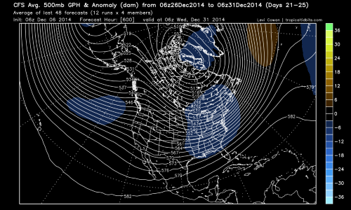
TropicalTidbits.Com (Levi Cowan) (3)
After the barrage of seemingly endless computer model runs that indicated a long spell of mild temperatures across the continent, quite a few people who review or forecast weather threw out their winter forecasts. Out went the mostly "cold and snowy" descriptions, in came the terms of "blowtorch" and "balmy" for the DJF period 2014-2015. As I have often cautioned in releasing my predictions, outcomes shown by the numerical depictions are often short-term deviations from what eventually occurs.
After the barrage of seemingly endless computer model runs that indicated a long spell of mild temperatures across the continent, quite a few people who review or forecast weather threw out their winter forecasts. Out went the mostly "cold and snowy" descriptions, in came the terms of "blowtorch" and "balmy" for the DJF period 2014-2015. As I have often cautioned in releasing my predictions, outcomes shown by the numerical depictions are often short-term deviations from what eventually occurs.
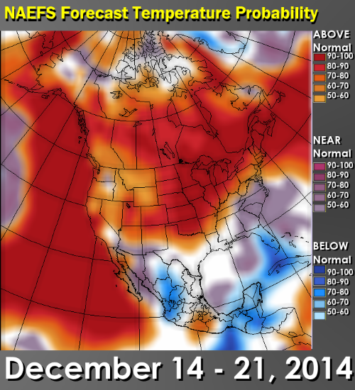
So it should come as little surprise that beginning with the Friday 12z December 5 model runs, signs of high-latitude ridging, southern branch storminess and a slow decline in temperature were seen in the 11 - 15 day time frame. These shifts continued through Saturday, and affirms my belief that we are indeed headed into a "rough patch' covering the last week of December, and most of January, February into the first half of March. I have not changed my winter outlook one iota, for the reason that I thought there would be an extensive mild phase in this month that ultimately gave way to Arctic air and cases for more widespread snow.
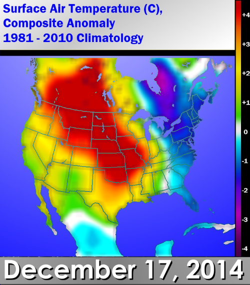
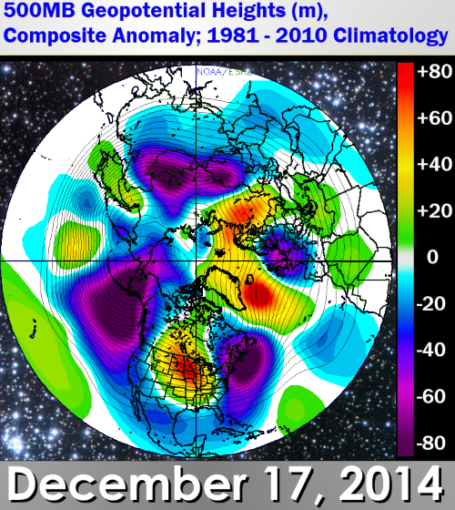
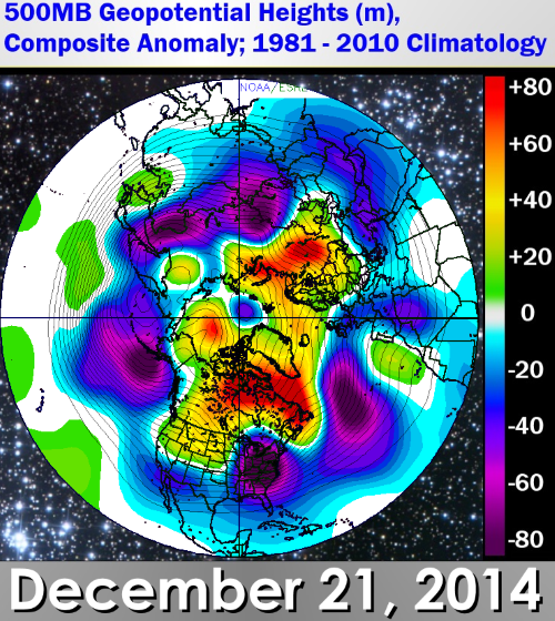
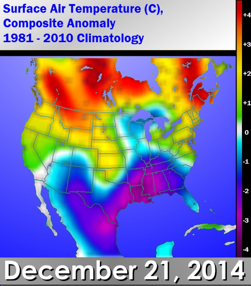
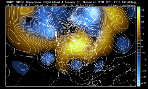
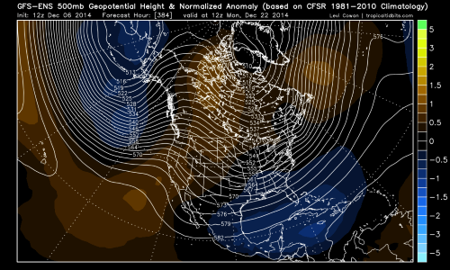
The reason why the current "El Nino" type configuration (split flow with mild ImP and mT air mass dominance) will shift to a highly amplified set-up featuring +PNA, -AO, and -NAO elements has to do with the active southern branch flow. What the models, and the analog formula, are saying is that a stronger disturbance will take shape in Texas, swing through the Deep South, and then move up along and off of the Eastern Seaboard. I am uncertain as to which particular storm will be the change mechanism, but the analog sample (20 members) points toward a new shortwave moving out of northern Mexico on December 17, translating to a colder, stronger low pressure center near Cape Hatteras NC on the 21st. Perhaps it is the same feature shown by the ECMWF model family over Texas in ten days. But I call your attention to the fact that when you compare ALL of the numerical versions to the analog-derived forecast, you see how very similar the maps are. Most notable: besides the storm threat, check out the extensive high-latitude ridge display. Yes, +PNA, -AO, -NAO coming up on tap!
I am not predicting a rapid change to a colder scenario in the U.S., but insist that the southern branch storm system will be the catalyst. This impulse may become an entrenched cA vortex over QC and ON at some point in the last week of December, after bringing copious amounts of rain with some inland snows. The snowpack should start to increase in coverage over the Midwest, Great Lakes and Appalachia during the 11 - 15 day time frame, leading of course to colder temperature forecasts east of the Rocky Mountains. I suspect we are going to be dealing with a mild West vs. cold Central and East set-up by Christmas Day.
All I want for Christmas is 498dcm cAk 500MB vortex over Lake Michigan....and a moderate Modoki El Nino with a persistent moisture fetch from the Caribbean Sea to the Grand Banks.
You can figure it out. :)
Prepared by Meteorologist LARRY COSGROVE on
Saturday, December 6, 2014 at 8:55 P.M. CT
Disclaimer:
The previous statements are my opinions only, and should not be construed as definitive fact. Links provided on this newsletter are not affiliated with WEATHERAmerica and the publisher is not responsible for content posted or associated with those sites.
Copyright 2014 by Larry Cosgrove
All rights reserved.
This publication may not be reproduced or redistributed in whole or in part without the expressed written consent of the author.
This publication may not be reproduced or redistributed in whole or in part without the expressed written consent of the author.
Reply all
Reply to author
Forward
0 new messages