Skip to first unread message

SBitz
Dec 18, 2017, 4:23:33 AM12/18/17
to sb...@googlegroups.com
"Mending Monday" we hope. Plenty of mop up and containment to do before the wind event forecast closing in on the Thomas Fire area. I'll post some info to fill in how things look at the moment.
SBitz
Dec 18, 2017, 4:31:35 AM12/18/17
to Santa Barbara CitiZen Network
Good news right off the bat. The GOES InfraRed fire detection satellite shows no hint of significant heat anywhere in the fire area, even with the brightness pumped way up in this 12:30am image. In fact, none detected anywhere in California. This means no fire suppression resources are being diverted to fight other fires, so they can focus on working to keep the Thomas Fire from jumping containment lines when the wind starts again.
SBitz
Dec 18, 2017, 4:38:13 AM12/18/17
to Santa Barbara CitiZen Network
Like the IR sat image in the prior post, the light sensitive night camera on Broadcast Peak is black except for city lights, even with the brightness pumped way up. The points of light are stars again, rather than hillsides dotted with spot fires. The smoke has cleared considerably too.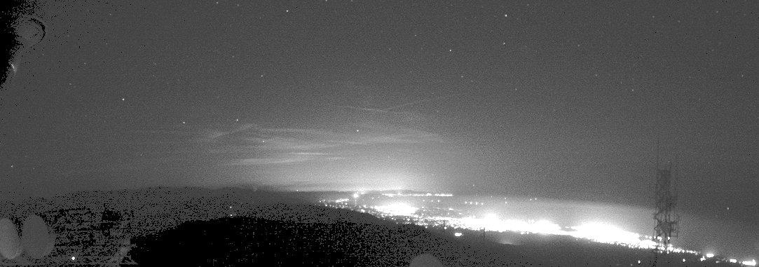
SBitz
Dec 18, 2017, 5:11:22 AM12/18/17
to Santa Barbara CitiZen Network
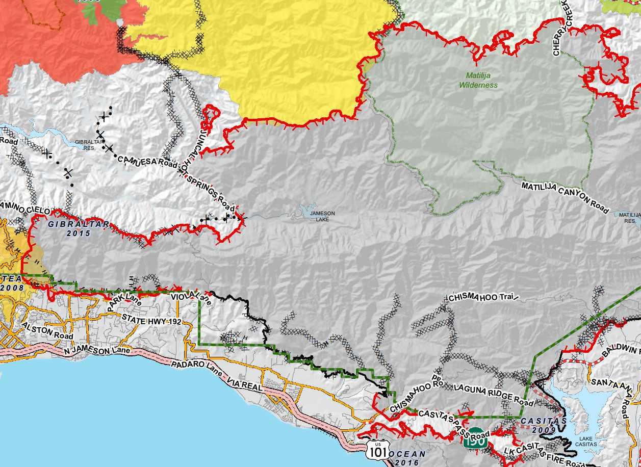
Here's the 12/17 map of the Thomas Fire area in the Southeastern part of Santa Barbara County and into the Southwestern part of Ventura County. The large gray blob is Thomas, and other historic fire perimeters in this region are depicted in different colors, except the 2016 Ocean Fire at the bottom-right which is also in gray. Of most interest to Montecito residents is how well that finger pointing West was contained during the powerful Saturday wind storm. They kept it from leaping across the ridge at Camino Cielo Road to the North, the more densely populated area on the South line above Hwy. 192, and even kept it from spreading further West. Heroic work in 70mph wind gusts and low humidity in bone dry and dead fuel!
SBitz
Dec 18, 2017, 5:15:09 AM12/18/17
to Santa Barbara CitiZen Network
The most important thing for today is to strengthen containment lines and extinguish lingering hotspots. Arduous work in steep terrain. Success today and into Tuesday may mean that skies will clear and we have a good chance of no fire spread during the coming wind event. If so, the worst we might have ahead is ash clouds kicked up by the wind, and a massive slope remediation project to avert flooding when the rains hopefully arrive.

Section Make8R
Dec 18, 2017, 10:48:19 AM12/18/17
to Santa Barbara CitiZen Network
On Monday, December 18, 2017 at 2:15:09 AM UTC-8, SBitz wrote:
The most important thing for today is to strengthen containment lines and extinguish lingering hotspots. Arduous work in steep terrain. Success today and into Tuesday may mean that skies will clear and we have a good chance of no fire spread during the coming wind event. If so, the worst we might have ahead is ash clouds kicked up by the wind, and a massive slope remediation project to avert flooding when the rains hopefully arrive.
Thanx for daily updates!!! I'm looking forward to Sleepy Saturday and Snoozing Sunday. My feeling about the next wind event from looking at my ocean models and the NWS forcast from below, is that the wind event will be about 20-40% less in strength. Wave heights much less from NW component and it seems that as it shifts to the North,the gusts etc are much less. NWS mentions the freeway 5 corrdor which is good sign for us,
NWS Oxnard short version:
622 AM PST Mon Dec 18 2017

.SYNOPSIS...
Gusty northeast winds across portions of Ventura and Los Angeles
Counties will diminish this morning, then tranquil weather is
expected through Tuesday. High temperatures will be near to
slightly above normal through Tuesday. It will be chilly tonight.
An upper trough passing to the north of the region may bring some
showers to northern areas and the mountains Wednesday. Gusty north
winds are expected late Wednesday into Wednesday night, followed by
gusty northeast winds Thursday. Offshore flow will continue into
the weekend.

&&

.SHORT TERM...(TDY-WED)

With the exception of some high clouds streaming into the region
from the northeast, skies were clear across the forecast area early
this morning. Today should be a mostly sunny day. Gusty northeast
winds continued to affect much of Ventura County, the mountains
of Los Angeles County including the Santa Monica Range and the
Santa Clarita Valley. A wind advisory remains in effect in these
areas through mid morning, but winds will be in the low end of the
advisory range, and nothing like the winds observed on Sunday.
Winds should diminish below advisory levels in most areas by mid
morning. After a chilly morning, with areas of frost on the Central
Coast and freezing temps in the Santa Ynez and Cuyama Valleys, it
should warm nicely in most areas today. Max temps should be 5-10
degrees higher than those on Sunday in the mtns, deserts, and
interior valleys, and a few degrees higher than those on Sunday
elsewhere. The exception will be across portions of the coastal
plain, mainly near the coast, where max temps should be about the
same.

The upper ridge building across the region today will flatten out
tonight and Tuesday as an upper low approaches the Pacific
northwest. With clear skies, light winds, and continued very dry
conditions, tonight will again be rather chilly and frost
advisories may be needed for the Central Coast and possibly the
Ojai Valley. Freezing conds are possible in the Santa Ynez Valley.
Do not expect any low clouds tonight as gradients will remain
weakly offshore. Pressure gradients turn onshore Tuesday
afternoon  and heights/thicknesses begin to fall. Expect a few
degrees of cooling in all areas west of the mtns on Tue, with
little change or possibly slightly warming in the mtns and
deserts as 850 mb temps rise a bit.

The upper low will move into the Pac NW Tue night, then drop into
the Great Basin on Wed with the trough axis extending south
southwestward into forecast area. Expect low clouds to develop on
the Central Coast and across coastal sections of L.A. and VTU
Counties Tue night, possibly pushing into some valley locations.
The southern end of a surface front associated with the trough
could bring some showers to areas north of Point Conception
Wednesday into Wed evening, and possibly to the northern slopes of
the mtns of VTU County and northwestern L.A. County Wed afternoon
and evening. Skies will be partly cloudy elsewhere. There will be
several degrees of cooling in all areas Wed. Gusty northwest to
north winds are expected to develop across much of SBA and SLO
Counties and through the Interstate 5 Corridor during Wed
afternoon.
SBitz
Dec 18, 2017, 4:26:30 PM12/18/17
to Santa Barbara CitiZen Network
Sure is looking better today! Some info I've been collecting:
*The helicopters were flocking at Salvar Bridge ("to nowhere") again this morning, but stopped recently (lunch break?).
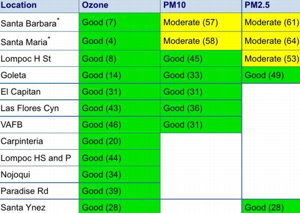
*Air Quality at noon was the best in quite a while, with a rating of "Moderate" for both particulate sizes in Santa Barbara.
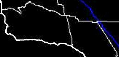
*This 12:30pm "shortwave" (closer to visible light) "albedo" (refracted light) InfraRed satellite for our region shows a flare up in Ventura County, while also giving a good indication of what the thinning smoke and ash plume looked like an hour ago. I've tweaked the black level up some to better reveal the smoke.
*The helicopters were flocking at Salvar Bridge ("to nowhere") again this morning, but stopped recently (lunch break?).
*Air Quality at noon was the best in quite a while, with a rating of "Moderate" for both particulate sizes in Santa Barbara.
*This 12:30pm "shortwave" (closer to visible light) "albedo" (refracted light) InfraRed satellite for our region shows a flare up in Ventura County, while also giving a good indication of what the thinning smoke and ash plume looked like an hour ago. I've tweaked the black level up some to better reveal the smoke.

Pork Rind
Dec 18, 2017, 4:39:35 PM12/18/17
to Santa Barbara CitiZen Network
From my home office I have a nearly direct view north to Lauro Reservoir. Two black and white helicopters, N802PJ and N803PJ are using the reservoir as a dip site to fill their bukets. I should time it, but it sure feels like their round trip is less than five minutes. I've gotten to where I don't look up any longer when they buzz into sight. I can hear them talking to ground crews and they are busy hitting hot spot after hot spot.
I went out to a farm my wife helps manage up the foothills of Carpinteria. I spent some time hiking the new firebreaks the dozers and ground crews hacked out. I'm impressed with by a couple of details. First, the precision. There are multiple areas where the fire scar goes right up to a property line or other established perimeter and stops dead right there. Pretty amazing. Second, some of the dozer paths are incredibly steep. I had no idea that the equipment could traverse those angles, much less work at them.
If any of the photos are any good, I'll post later today after work.
SBitz
Dec 18, 2017, 5:11:49 PM12/18/17
to Santa Barbara CitiZen Network
using the reservoir as a dip site
spent some time hiking the new firebreaks
Thanks for your on-site report. We might fly over for some aerial shots today, and like you will post anything worthwhile after down-sizing it to help those with slow net connections. I liked Topix' idea of a small pic with link to larger version too, but so far my preference has been to crop/down-size on areas of interest. Anyone have opinions, requests or comments on this notion of keeping file sizes small during the evacuations?
some of the dozer paths are incredibly steep.
My wife exclaimed about that while watching some of the extensive KEYT coverage. I didn't say anything, but occasionally one of those dozers takes a tumble and the outcome can be tragic. So much courage routinely exhibited by fire and police personnel. Not to mention their endurance and that of the countless people supporting their efforts. Inspiring!
SBitz
Dec 18, 2017, 5:32:21 PM12/18/17
to Santa Barbara CitiZen Network
Now that things are relatively calm I've been rummaging the CalFire site, and see their home page has links to helpful info including one titled "Returning Home After A Wildfire" (click to download PDF). Their Fire Map page has some great current and historical stuff too, though it's a little resource and data intensive if you have limited internet or computer resources. I noticed during the fire that the other major government fire site named InciWeb seemed to play leapfrog with CalFire with the latest info and they each have different stuff so I check them both.
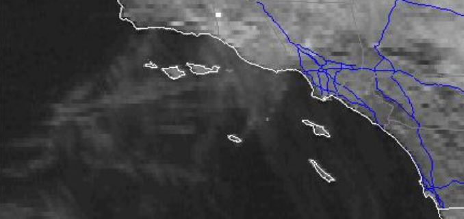
Meanwhile, this 1:30pm GOES IR sat (brightness unchanged) showed another hotspot in Ventura County. Maybe controlled "back burn" in preparation for the coming wind event?

Meanwhile, this 1:30pm GOES IR sat (brightness unchanged) showed another hotspot in Ventura County. Maybe controlled "back burn" in preparation for the coming wind event?
Pork Rind
Dec 18, 2017, 5:43:54 PM12/18/17
to Santa Barbara CitiZen Network
None of these are particularly spectacular, but there might be a little interest here. These are just quick shots around a farm in the Carp foothills. 742 and 743 in particular show how tight the fire crews held the activity right up to the property line. 746 is a view hard to convey in a photograph; a dozer track so steep I didn't care to try to walk up it. 766 is a view up a new dozer track that links to similar new cuts up in the hills. Once the forest is reopened, I look forward to hiking up these as the trails up to this ridge were badly overgrown. Now I practically have a highway to poke along.
758 is of a car that I first thought was parked in the wrong place at the wrong time. The bullet holes suggest that it's been there much longer than I originally thought.
Thumbnails here, large photos at the link...


Section Make8R
Dec 18, 2017, 5:52:57 PM12/18/17
to Santa Barbara CitiZen Network
On Monday, December 18, 2017 at 2:32:21 PM UTC-8, SBitz wrote:
Now that things are relatively calm I've been rummaging the CalFire site, and see their home page has links to helpful info including one titled "Returning Home After A Wildfire" (click to download PDF). Their Fire Map page has some great current and historical stuff too, though it's a little resource and data intensive if you have limited internet or computer resources. I noticed during the fire that the other major government fire site named InciWeb seemed to play leapfrog with CalFire with the latest info and they each have different stuff so I check them both.
Meanwhile, this 1:30pm GOES IR sat (brightness unchanged) showed another hotspot in Ventura County. Maybe controlled "back burn" in preparation for the coming wind event?
Quick update, west winds, cooler, but dry now 24% RH. Evac order lifted for my neighborhood, but the back and forth between folks in charge does get confusing. People were turned away with the correct address too!!!
After, that...chaos, SanYsidro was like a racetrack with people coming in. I stood out in the street to verify for people, that yes, it IS open. I guess myplant to smuggle champagne and special items through the tunnel network will just have to wait!!! (I went under the 101 this am to check and see if it was doable....keep it secret though )
Lets hope that wind event is not what it could be.... the last one could have been SO MUCH worse, if the winds can come straight line North down tothe beach, be interesting to see why they have veered over to East to West during the Tea Fire and now the Thomas. 60mph winds and not a thing down here.
Ok off to tend everything....thanks guys.
SBitz
Dec 18, 2017, 9:22:35 PM12/18/17
to Santa Barbara CitiZen Network
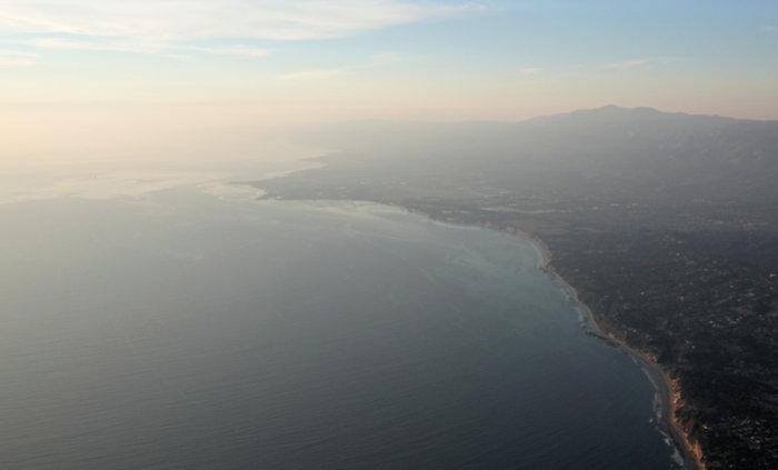
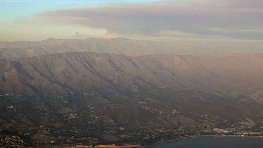
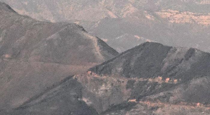
Thanks for the posts. We flew up along the South edge of the TFR this evening about 4pm and got these pix. Didn't have time to climb up over it. Pretty smoky so they're fairly tweaked to show some detail. Alas, I didn't get any of the Gibraltar area. :(


topix
Dec 18, 2017, 9:54:37 PM12/18/17
to Santa Barbara CitiZen Network
Here's a few impressions from the community briefings at 4 and 6pm today.
The fire seems to have turned a corner. 50% containment at 271,000 acres. It will still take several weeks for it to be 100% contained and, more importantly, entirely out. (est. Jan 7). However, firefighters are being sent home (there were over 8500 personnel here; many 1000s will still be here to fight on when the winds return on Wed).
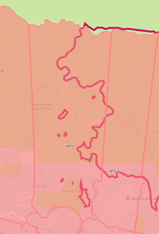
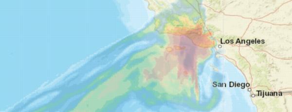
As of today (Monday), active fire areas (in SB county) seem to be in two locations: (1) the western head (west Montecito near Westmont/Parma Park/Gibralter Road/Flores Flats) which remains a priority for firefighters on Tuesday [see image from the evac map, below] and (2) the northwestern edge (Hwy 33 in the back country) parts of which firefighters actually burned on purpose today. The fire is still pretty active on the NE/Ventura front, in places like Sespe Creek.
The fire seems to have turned a corner. 50% containment at 271,000 acres. It will still take several weeks for it to be 100% contained and, more importantly, entirely out. (est. Jan 7). However, firefighters are being sent home (there were over 8500 personnel here; many 1000s will still be here to fight on when the winds return on Wed).
As of today (Monday), active fire areas (in SB county) seem to be in two locations: (1) the western head (west Montecito near Westmont/Parma Park/Gibralter Road/Flores Flats) which remains a priority for firefighters on Tuesday [see image from the evac map, below] and (2) the northwestern edge (Hwy 33 in the back country) parts of which firefighters actually burned on purpose today. The fire is still pretty active on the NE/Ventura front, in places like Sespe Creek.
topix
Dec 18, 2017, 10:14:42 PM12/18/17
to sb...@googlegroups.com
Although many evacuation orders remain in place, a few have lifted, and the fire team expects to have all evac orders lifted by Friday.
Carp has had all evac orders lifted (voluntary and mandatory).
A southern portion of Montecito will be opened to the public on Tuesday morning at 6am.
Beginning at 6am tomorrow (Tue Dec 19), Coast Village Road (incl Coast Village Circle) between Olive Mill Rd and Hot Springs Rd will be opened to ALL persons.
HOWEVER, no roads traveling north from Coast Village Road will be opened.
here's the official notice: https://pbs.twimg.com/media/DRYCZ1OV4AARWYm.jpg
For Santa Barbara, the spokesman @SBCityOES_RH tweeted that "The VOL. EVAC WARNING for portions of SB City has been lifted. This
includes the area from Constance/Alameda Padre Serra/South Salinas on
the north and east, Highway 101 on the south, and W. Mission St. to
State Street on the west."
You can check the map to get the latest details.
( http://www.arcgis.com/apps/webappviewer/index.html?id=d11dd89a72594d54a3b377d9978f7765&extent=-13331537.0594,4076617.8896,-13292401.3009,4101765.6719,102100 )
( http://www.arcgis.com/apps/webappviewer/index.html?id=d11dd89a72594d54a3b377d9978f7765&extent=-13331537.0594,4076617.8896,-13292401.3009,4101765.6719,102100 )
topix
Dec 18, 2017, 10:23:44 PM12/18/17
to sb...@googlegroups.com
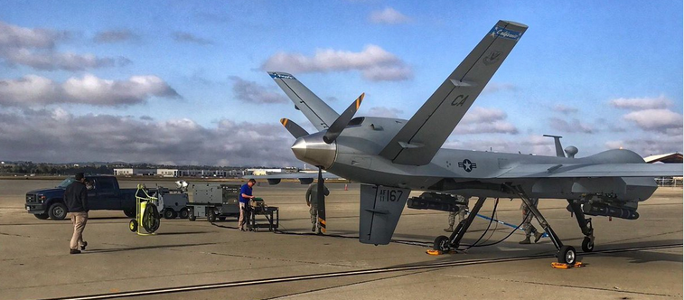
Thanks for the aerial shots, SBitz. Here's one for you. A shot of the infrared-enabled USAF Reaper drone that has been mapping hot spots that tell our flight and ground crews exactly where to attack.
(Attention radar junkies, I understand that this thing does its recon around 2am...I, for one, am looking forward to being sound asleep tonight for a change!)
full story on facebook https://t.co/3d5ka4k9ZQ
(Attention radar junkies, I understand that this thing does its recon around 2am...I, for one, am looking forward to being sound asleep tonight for a change!)
full story on facebook https://t.co/3d5ka4k9ZQ
Pork Rind
Dec 18, 2017, 11:35:33 PM12/18/17
to Santa Barbara CitiZen Network
Oh wow, that's fantastic. I'd love to track that, but not so much as to roll out of bed at that time.
SBitz
Dec 19, 2017, 12:11:20 AM12/19/17
to Santa Barbara CitiZen Network
Fun posts everyone's added today. :)
Topix taunted:
Topix taunted:
USAF Reaper drone that has been mapping hot spots
Glad you waited until I'm too tired for the late shift, or I'd probably be tracking it and watching outside with my longest lens. We could fly up and challenge it, but that looks like a missile hanging underneath and our arming crew is on leave for holidays. ;)
BTW, I made some of your web addresses (URLs) into active links again. It's easy on the web interface, but using email to post as I often do takes some nerd inclination. Whatever URLs anyone posts in any format are most welcome, and my obsession can be fed by "linkifying" some occasionally (other nerds are welcome to join me in that :)
topix
Dec 19, 2017, 12:38:16 AM12/19/17
to sb...@googlegroups.com
Right, the only droning any of us will doing tonight will look like this zzzzzzz (yup, that's a link!)
(you might want to try that link again...I didn't make it specific enough originally)
SBitz
Dec 19, 2017, 12:41:05 AM12/19/17
to Santa Barbara CitiZen Network
This 8:30pm GOES hi band IR (I pumped the image file brightness up some) that better shows some hotspots, smoke and clouds looks pretty quiet and the black streaks offshore seem to indicate wind is still taking smoke away from SB.

The view East from the Broadcast Peak night camera (brightness unchanged) is verging on normal. Certainly compared with the last two weeks. The stars are brighter tonight.

Here's how NOAA predicted smoke in the air column to look at 4pm when we snapped those aerial pix today. I turned down the smoke density so you can make out our coastline.
This 8pm AQI report is better than we've seen for a while too, but actually up a tad from earlier this evening as the smoke and ash slosh around in the atmosphere. Still prudent to wear the N95 masks outside, because the lingering smoke plus ash stirred up by cars (and leaf blowers! - shaking my head in disbelief) still carries harmful particles.
OK, I'm offline now and don't know about checking back later. Rather tired. :}
Good night all, and thanks to everyone who's posting and all who've signed up as Members to encourage us.
The view East from the Broadcast Peak night camera (brightness unchanged) is verging on normal. Certainly compared with the last two weeks. The stars are brighter tonight.
Here's how NOAA predicted smoke in the air column to look at 4pm when we snapped those aerial pix today. I turned down the smoke density so you can make out our coastline.
This 8pm AQI report is better than we've seen for a while too, but actually up a tad from earlier this evening as the smoke and ash slosh around in the atmosphere. Still prudent to wear the N95 masks outside, because the lingering smoke plus ash stirred up by cars (and leaf blowers! - shaking my head in disbelief) still carries harmful particles.
OK, I'm offline now and don't know about checking back later. Rather tired. :}
Good night all, and thanks to everyone who's posting and all who've signed up as Members to encourage us.
SBitZ.NET
Dec 19, 2017, 2:12:37 AM12/19/17
to Santa Barbara CitiZen Network
Just came across some scary numbers:
*Since 1984 the area that burns is up 300%, and the area of forests that
burns is up 1,000%.
-Alton Park Williams PhD,
Lamont-Doherty Earth Observatory,
Biology and Paleo Environment,
Columbia University
I hope he's wrong, or at least that the numbers shift the other way in
coming decades.
*Since 1984 the area that burns is up 300%, and the area of forests that
burns is up 1,000%.
-Alton Park Williams PhD,
Lamont-Doherty Earth Observatory,
Biology and Paleo Environment,
Columbia University
I hope he's wrong, or at least that the numbers shift the other way in
coming decades.
Reply all
Reply to author
Forward
0 new messages