Skip to first unread message

tao hu
Sep 10, 2019, 9:14:05 PM9/10/19
to Dataverse Users Community
Hi
I follow the instructions to install the Dataverse and Geoconenct. Both works fine seperately. However, I met two problems when processing the spatial data.
(1) When I upload and save the csv file with latitude and longitude, it keeps showing "ingest in progress" and doesn't disappear on the interface.
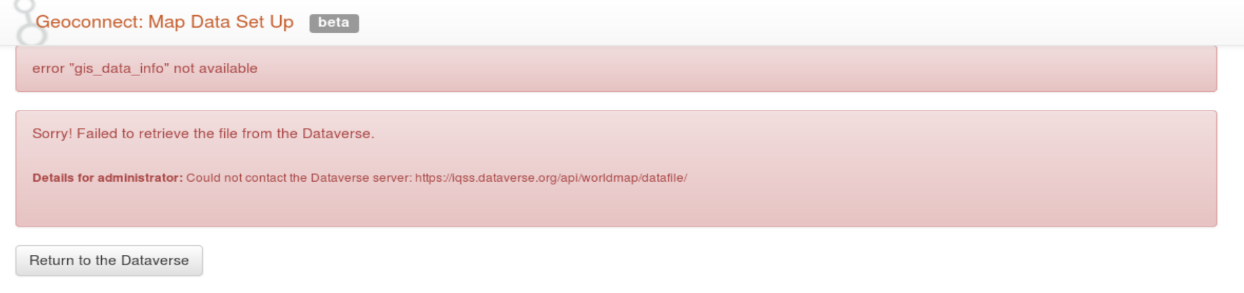
(2) I upload the zip file with shapefile and try to view on the map, it shows "error gis_data_info not available; failed to retrieve the file from the dataverse".
Both errors are screenshot in the attachment. Hope someone can help me to figure out the problem. Thank you so much.
Tao

Philip Durbin
Sep 10, 2019, 9:47:56 PM9/10/19
to dataverse...@googlegroups.com
Hmm, about two months ago I successfully created a map on the Dataverse demo site: https://demo.dataverse.org/dataset.xhtml?persistentId=doi:10.70122/FK2/HI5BF1
My map was also a tabular file with lat/long columns (of Dataverse installations around the world).
Can you please try testing it there on the demo site to see if it works?
Thanks,
Phil
--
You received this message because you are subscribed to the Google Groups "Dataverse Users Community" group.
To unsubscribe from this group and stop receiving emails from it, send an email to dataverse-commu...@googlegroups.com.
To view this discussion on the web visit https://groups.google.com/d/msgid/dataverse-community/ae6c65f2-ab0b-4919-83c2-64fd911ab6d2%40googlegroups.com.
--
Philip Durbin
Software Developer for http://dataverse.org
http://www.iq.harvard.edu/people/philip-durbin
Software Developer for http://dataverse.org
http://www.iq.harvard.edu/people/philip-durbin
tao hu
Sep 11, 2019, 10:31:07 AM9/11/19
to Dataverse Users Community
Hi Phil
Thank you so much for your reply. I test the data in the Dataverse demo, it also has problem in ingesting. When I download the test spatial data in Dataverse demo and upload to my local Dataverse, the ingesting works good. However, the error 'gis_data_info not available' is still there when I view the data on the map. Is there any problem with the hostname that I set, iqss.dataverse.org? It doesn't have port number.
Best,
Tao
Philip Durbin
Sep 11, 2019, 4:39:32 PM9/11/19
to dataverse...@googlegroups.com
Hi Tao,
So nice meeting you and so convenient that you're in my building!
I'm very glad we got this working (the usual culprit, the JVM option dataverse.siteUrl was to blame) and that you've now got a Geoconnect dev environment working!
Go, go, go!
Phil
--
You received this message because you are subscribed to the Google Groups "Dataverse Users Community" group.
To unsubscribe from this group and stop receiving emails from it, send an email to dataverse-commu...@googlegroups.com.
To view this discussion on the web visit https://groups.google.com/d/msgid/dataverse-community/65a852eb-4aa6-4a6e-b327-286ce7f9d8fe%40googlegroups.com.
tao hu
Sep 11, 2019, 4:53:14 PM9/11/19
to Dataverse Users Community
Hi Phil
Great to see you, too! Appreciate your help. It will take a long time to figure out the problem without your support.
I have tested the spatial data connecting to own test WorldMap. The shapefile works fine, but the .tab/.csv file doesn't. It looks like the WorldMap has a problem when ingesting lat/lng data. I will check it out.
Almost there : )
Best,
Tao
Reply all
Reply to author
Forward
0 new messages