Ground Overlay with gx:LatLonQuad

zch...@gmail.com
Recently we tried many GoogleEarth alternatives (including ArcGis, SharpMap, etc...), but none of them was good enough to replace it.
We are still using googleEarth, but the clock is ticking and we decided to try Cesium.
For now, it looks very promising!
One of the problems we try to solve is to correctly show objects represented with this KML:
<GroundOverlay id="a6925dcd-9c68-437a-9e90-8167a178c0e9">
<name>Overlay</name>
<visibility>0</visibility>
<Icon>
<href>http://127.0.0.1:14499/frame.jpg</href>
<viewBoundScale>0.75</viewBoundScale>
</Icon>
<gx:LatLonQuad>
<coordinates>
-125.7948791,31.7647378,0
-125.7948905,31.7663583,0
-125.7995141,31.7679331,0
-125.7984818,31.7645867,0
-125.7948791,31.7647378,0
</coordinates>
</gx:LatLonQuad>
</GroundOverlay>
What is correctly shown in cesium:
1. gx:LatLonQuad is shown properly
2. Icon/href image is also retrieved (CORS is enabled on the server)
What's wrong:
1. Icon/href is not shown correctly. It looks like it is cropped instead of transformed.
I know that in the current KML implementation this specific feature is not implemented.
Are there some workarounds that may help me to achieve this goal (to show the image on gx:LatLonQuad), and which would be the best?

Hannah Pinkos
zch...@gmail.com
Thank you for the quick response.
Here is the screenshot made in google earth with correctly shown kml:
http://s32.postimg.org/q6scdxldx/ge_example.png
and here is the same kml in cesium:
http://s32.postimg.org/ihmru3n2d/cz_example.png
Here is the whole kml file content:
<kml xmlns="http://www.opengis.net/kml/2.2" xmlns:gx="http://www.google.com/kml/ext/2.2" xmlns:kml="http://www.opengis.net/kml/2.2" xmlns:atom="http://www.w3.org/2005/Atom">
<GroundOverlay id="69b165f9-05d7-44a7-b672-d7159cc523aa">
<name>Overlay</name>
<visibility>1</visibility>
<Icon>
<href>test_frame.jpg</href>
<viewBoundScale>0.75</viewBoundScale>
</Icon>
<gx:LatLonQuad>
<coordinates>
-121.7948791,36.7647378,0
-121.7948905,36.7663583,0
-121.7995141,36.7679331,0
-121.7984818,36.7645867,0
-121.7948791,36.7647378,0
</coordinates>
</gx:LatLonQuad>
</GroundOverlay>
</kml>
and this is test_frame.jpg
http://s32.postimg.org/gly5dg2h1/test_frame.jpg

Scott Reynolds
KML - gx:LatLonQuad Icon does not support texture projection.
zch...@gmail.com
I know for that limitation.
Is there some workaround that will allow me to achieve the same result as in GoogleEarth?
Maybe by using CZML, or some custom geometry, or writing some custom shader/renderer, or something else?
Hannah Pinkos
zch...@gmail.com
We warped input image in the way it fits to the groundOverlay in the same way as in googleEarth.
After transformation our image looks like:
http://s32.postimg.org/5h6jitcat/test_frame_warped.png
That works, but it isn't elegant solution because we had to add another layer of abstraction that changes our input image.
There are few of us here that are willing to try to implement at least a custom geometry type with correct texture coordinates (we don't explicitly need to do this through the kml), so any additional information and resources are welcome :)
Hannah Pinkos

nikos....@gmail.com
reviving this as I want to know if there are any new developments in this area. I'm trying to visualizes some ground overlays which we used to overlay using google earth. Cesium doesn't seem to apply any rotation. Bellow is an example where you can see that the image inside the box isn't rotated as it should:
https://dl.dropboxusercontent.com/u/10965353/Screen%20Shot%202017-02-13%20at%2018.00.03.jpg
Hannah Pinkos
nikos....@gmail.com
http://citisens.eu/rotation.jpg
Hannah Pinkos
Nikos Bogdos
--
You received this message because you are subscribed to a topic in the Google Groups "cesium-dev" group.
To unsubscribe from this topic, visit https://groups.google.com/d/topic/cesium-dev/x3sYLgIr8Mc/unsubscribe.
To unsubscribe from this group and all its topics, send an email to cesium-dev+...@googlegroups.com.
For more options, visit https://groups.google.com/d/optout.
nikos....@gmail.com
My problem now is that although the screen overlay displays OK when terrain view is disabled, when I enable a terrainProvider the overlay isn't clamped to the ground despite setting the clampedToGround option to true in the KmlDataSource.load options. I tried this with other types of KMLs that we use (vector types, polygons, etc.) and the problem remains.
Please tell me that I'm doing something wrong and that the "clamped to ground" functionality is supported is some way.
Hannah Pinkos
Nikos Bogdos
var terrainProvider = new Cesium.CesiumTerrainProvider({requestVertexNormals : true});var viewer = new Cesium.Viewer('cesiumContainer', {baseLayerPicker : false,terrainProvider : terrainProvider});var options = {
camera : viewer.scene.camera,canvas : viewer.scene.canvas,clampToGround : true
};viewer.dataSources.add(Cesium.KmlDataSource.load('https://dl.dropboxusercontent.com/u/10965353/slope.kml', options));
nikos....@gmail.com
did you notice the problem using the files I gave you? I have the same problem when using KMLs containing polygon coordinates (no overlays). The polygons are still not clamped to the ground even when I use the clampedToGround option.
Hannah Pinkos
Nikos Bogdos
Hannah Pinkos
var viewer = new Cesium.Viewer('cesiumContainer');var options = { camera : viewer.scene.camera, canvas : viewer.scene.canvas, clampToGround: true};
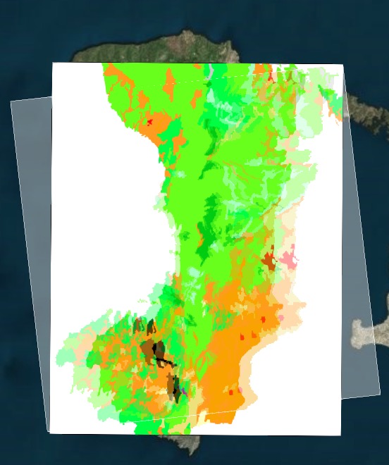
var ds = viewer.dataSources.add(Cesium.KmlDataSource.load('../../SampleData/kml/fireProb-3.kml', options));viewer.zoomTo(ds);Nikos Bogdos
var terrainProvider = new Cesium.CesiumTerrainProvider({requestVertexNormals : true});var viewer = new Cesium.Viewer('cesiumContainer', {baseLayerPicker : false,terrainProvider : terrainProvider
});var options = {camera : viewer.scene.camera,canvas : viewer.scene.canvas,clampToGround : true};var ds = viewer.dataSources.add(Cesium.KmlDataSource.load('../../SampleData/kml/fireProb-3.kml', options));viewer.zoomTo(ds);
Hannah Pinkos
Sorry, I did enable terrain, I just didn't include that in my code snippet. Here's what I see:

What version of Cesium are you using, and what is your browser and operating system?