Inconsistent issue with "update edited field boundaries" utility

Kurt Stegemiller

Claudette Sandoval-Green
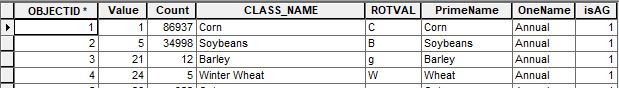
First, check the tables for each CDL and make sure that they each have the ROTVAL in the attribute tables.
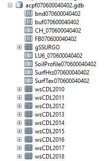
Send me a screenshot of your GDB from Catalog, for example like this screenshot below. I want to see everything in there after a bad run.
Thank you,
Claudette

David James
--
The ACPF Forum is an online group for discussing technical issues related to using the ACPF tools. Anyone can view the discussions at https://groups.google.com/a/umn.edu/d/forum/acpf-group. Only members can participate in discussions. Join the group by sending an email to acpf-group...@umn.edu
---
You received this message because you are subscribed to the Google Groups "ACPF Forum" group.
To unsubscribe from this group and stop receiving emails from it, send an email to acpf-group+...@umn.edu.
To view this discussion on the web visit https://groups.google.com/a/umn.edu/d/msgid/acpf-group/0fd177c6-0d8a-4baf-b483-1576da034f14n%40umn.edu.
Sandoval-Green, Claudette [A&BE]
Good morning,
I should have introduced myself, apologies, my friends call me the “Field Boundary Queen,” right, Dave?
Maybe that’s just me.
So, I think that the Update Edited Field Boundaries Tool processed just fine, Dave, but it ended way too quickly that can be a tell-tell sign of a few things that I have observed.
- The CDL tables are wrong. They processed incorrectly during the tool run. This can happen if the Soils tool is not run before the CDL tool. Email me and I’ll you my theory of why I think that happens. Maybe some has fixed it by now. At any rate, always run the tools in order.
- It the CDL tables are wrong, delete all of them in your FGDB and force the CDL tool to rebuild them brand new, and not replaced or copied over.
- This is a painful one, but this can happen for different reasons — there is no difference in the polygon count between FB############ and edit_FB############. Check the polygon count for each. The update tool is processing at lightning speed because there are no changes to update. If that’s the case, delete the FB############ and force the update field boundaries tool to rebuild anew.
- A bad FGDB – start over.
Send me a screenshot of your FGDB so I can tell you what cruff to delete – if any. You can email it to me.
I hope this helps.
C.
Claudette M.J. Sandoval-Green
(saan-doh-vaal)
GIS Database Development Specialist
Research Scientist II
Agricultural & Biosystems Engineering, 2333 Elings Hall
Iowa State University
Daily Erosion Project (DEP)
Agricultural Conservation Planning Framework (ACPF)
Web CV
Email: clau...@iastate.edu
Cell Phone: (515) 441-9707
(GIS DEP Techs can text me w/questions)
Cyclones Care: A Message from President Wendy Wintersteen
and Julia Campbell, Fall 2021

You received this message because you are subscribed to a topic in the Google Groups "ACPF Forum" group.
To unsubscribe from this topic, visit
https://groups.google.com/a/umn.edu/d/topic/acpf-group/LO0kYoQo0rs/unsubscribe.
To unsubscribe from this group and all its topics, send an email to
acpf-group+...@umn.edu.
To view this discussion on the web visit
https://groups.google.com/a/umn.edu/d/msgid/acpf-group/CAMu%2BuQZBv11V86EDyaxHreuX%2BVKi2X%2BtX10VYpzRkNCmSEvhoA%40mail.gmail.com.

Asell, Andy
- Convert your preliminary edited field boundaries to polylines, (Data Management Tools->Features->Feature to Line)
- Convert the polylines back to polygons and make this your FB_edit+HUC feature class for the U3 utility, (Data Management Tools->Features->Feature to Polygon)
- Start editing and select all features, then use the Explode command in the Advanced Editing Toolbar. I'll do this a few times...I like to have the table open to watch the poly record count. I keep "Exploding" until the poly count in the table doesn't change. Stop editing.

To view this discussion on the web visit https://groups.google.com/a/umn.edu/d/msgid/acpf-group/MN2PR04MB7071F7D8BC0F54BCE6287021C6A29%40MN2PR04MB7071.namprd04.prod.outlook.com.