Flow Paths Not Corrected by Cut Lines

Kurtis Fisher

Asell, Andy

--
The ACPF Forum is an online group for discussing technical issues related to using the ACPF tools. Anyone can view the discussions at https://groups.google.com/a/umn.edu/d/forum/acpf-group. Only members can participate in discussions. Join the group by sending an email to acpf-group...@umn.edu
---
You received this message because you are subscribed to the Google Groups "ACPF Forum" group.
To unsubscribe from this group and stop receiving emails from it, send an email to acpf-group+...@umn.edu.
To view this discussion on the web visit https://groups.google.com/a/umn.edu/d/msgid/acpf-group/19d4e3e0-7bd3-4bdc-ac2e-f952d17e2084n%40umn.edu.
Kurtis Fisher

David James
To view this discussion on the web visit https://groups.google.com/a/umn.edu/d/msgid/acpf-group/5592adcd-4845-4cc8-acf3-280e4ac14c15n%40umn.edu.

amarch...@gmail.com
On Mar 30, 2023, at 1:32 PM, Kurtis Fisher <kjfi...@catamount.wcu.edu> wrote:
Hi Andy,
To view this discussion on the web visit https://groups.google.com/a/umn.edu/d/msgid/acpf-group/5592adcd-4845-4cc8-acf3-280e4ac14c15n%40umn.edu.
<FlowPathNotCorrected_ManualCutterDamBuilderResults.jpg>
Asell, Andy
Kurtis Fisher
Kurtis Fisher
Kurtis Fisher
Asell, Andy
Agnieszka Marchlewska
David James
To view this discussion on the web visit https://groups.google.com/a/umn.edu/d/msgid/acpf-group/CAK4FnO%2BSV2rvfsDNLqE3R9N%2BOwS2_4q4GmWU96BsUfJiVXfAUA%40mail.gmail.com.
![McNeely, Robin L [DSN]'s profile photo](http://lh3.googleusercontent.com/a-/ALV-UjWvXRsbBibgokArwiQuPxgsNJTGsIkYzo6IYe19TLbWapEHzA=s40-c)
McNeely, Robin L [DSN]
Kurtis,
I will address a few of your recent emails. First, everything Andy Asell has mentioned about the DEM being integer, centimeter Z is what we encourage from the ACPF Hub. If the DEM is currently floating point, you get the detail that the hillshade will show but more importantly, what the tools will use. However, that creates a very large file size and slows processing. Our suggested solution is to convert the DEM to integer but in order to keep the elevation detail, also convert the Z units to centimeter.
When you do this, you can effectively use a 1m horizontal unit which means processing at the HUC12 level is fairly quick and you get the detail the tools need to do an effective job.
As long as you save your data to a local drive on your computer, no matter the actual drive letter, your processing will go faster. Writing data, or reading data from, a network drive is not recommended.
As for your last comment about not using a watershed within the ACPF database, that is fine if you are creating your own but please follow the manual recommendations. The tools’ ability to run depend on expected naming syntax so please use what we set up. It may help you to download a fgdb in the core dataset to have an example.
If you are still having issues after all the feedback you get, please reach out to acpfs...@iastate.edu and one of the Tech team can work with you individually.
|
Robin McNeely GIS Technical Team Lead mo...@iastate.edu Iowa State University National Hub for the Agricultural Conservation Planning Framework
|
From: acpf-...@umn.edu <acpf-...@umn.edu>
On Behalf Of Kurtis Fisher
Sent: Thursday, March 30, 2023 1:41 PM
To: ACPF Forum <acpf-...@umn.edu>
Cc: Kurtis Fisher <kjfi...@catamount.wcu.edu>;
amarch...@gmail.com <amarch...@gmail.com>; ACPF Forum <acpf-...@umn.edu>; Andy Asell <andy....@dnr.iowa.gov>
Subject: Re: [ACPF Forum] Flow Paths Not Corrected by Cut Lines
I see now that both amarch...@gmail.com and Dave James pointed out my naming convention. Will this actually cause processing issues? I'm not working from watersheds within the ACPF database so I don't have a Huc12 folder to work from like in the videos.
On Thursday, March 30, 2023 at 1:35:36 PM UTC-5 Kurtis Fisher wrote:
My impression was that 1 meter or above is too detailed for watershed delineation, and I thought it would made sense to work within the same resolution as the one in which I will delineate my watersheds to. Degrading to 5 meters from 1 meter resolution was actually a method I used to enhance my 10 meter resolution. I have been warned that 1 meter resolution will be too fine-scaled and will cause issues in the watershed delineation process. Correct me if I'm wrong.
On Thursday, March 30, 2023 at 1:28:55 PM UTC-5 Kurtis Fisher wrote:
D drive is my internal solid state drive. Is this not what is meant by a local drive? Should this always be C Drive, no matter what?
On Thursday, March 30, 2023 at 12:49:00 PM UTC-5 amarch...@gmail.com wrote:
I’m not sure but maybe the name of your files might be an issue here. Also D drive is not recommended. You should try to run it on the C drive. I’m not sure what is the issue with your DEM but the hillshade looks off to me too.
Sent from my iPhone
On Mar 30, 2023, at 1:32 PM, Kurtis Fisher <kjfi...@catamount.wcu.edu> wrote:
Hi Andy,
No, I didn't have a subset of lines selected. I actually made sure to clear all selected features at the end of each process for the sake of taking screen shots.
I'm not sure why that would be the case for my terraced-looking hillshade... I'm using a 5 meter resolution DEM which I generated from a 1 meter DEM with a pretty straightforward cubic resampling method in ArcGIS. I just redid the DEM Preparation steps with an unaltered 10 meter DEM. It ended up looking the same way, just with less resolution. That's an interesting note about my straight-shot lines though, I didn't know it wasn't supposed to work that way... Both DEMS came straight from The National Map, 3DEP quality.
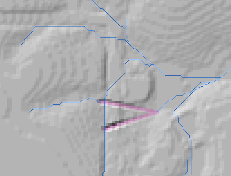
As far as the impeded flow, my cut lines did seem to make them disappear. So, my cut lines worked in a way, but I also need the flowlines to reflect these changes as I'll be using them to correct watershed boundaries in the catchment delineation process. Attached is the picture of my processing results.
Thanks,
-Kurtis Fisher
On Thursday, March 30, 2023 at 10:32:16 AM UTC-5 Andy Asell wrote:
Hmm, you didn't have a subset of your cutlines selected when you ran the Manual Cutter tool, did you? Another thing that looks kind of strange is your hillshade. It looks awfully "stair-steppy" (I'm having visions of rice paddies in China). It appears whatever algorithm used to generate the DEM/Hillshade didn't smooth out the elevations. Thus the reason you have a lot of "straight-shot" lines in your drainage network because they are running over areas of constant elevation. This would affect the viability of the TauDEM extensions when they're trying to model sheet flow. So the underlying original DEM might contribute to the wonkiness of some of your flowlines. But it doesn't answer your original question of why your cutter tool didn't take. Would you be able to reopen your last run of the Cutter too from the results tab and take a screenshot showing your inputs/outputs? Also, What does your updated "Identify Impeded Flow" based off your NewDEM look like after you've run the Manual Cutter?
To view this discussion on the web visit https://groups.google.com/a/umn.edu/d/msgid/acpf-group/755fb109-377e-4cf7-b3c6-5ddc0683185fn%40umn.edu.