Flood Inundation Products
134 views
Skip to first unread message

Kayla Yamamoto
Aug 3, 2022, 1:47:39 AM8/3/22
to wrf-hydro_users
Hi all,
I am interested in producing flood inundation maps that include both ponded water ('sfcheadsubrt') and riverine overbank flow, if possible.
I was under the impression that I would need to use a hydraulic model (e.g. HEC-RAS) that would use the WRF-Hydro output hydrograph as its input, to produce the riverine overbank flooding.
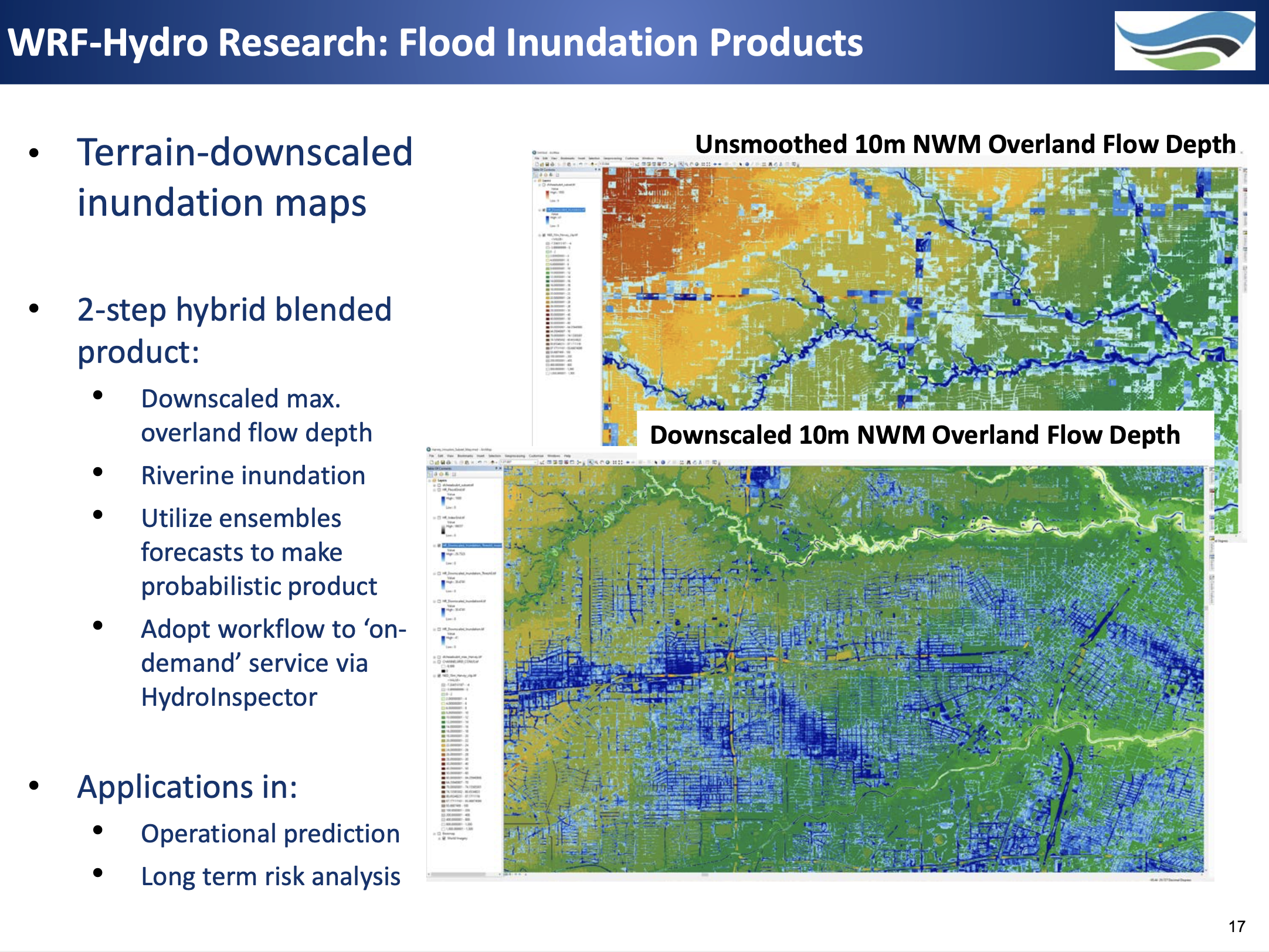
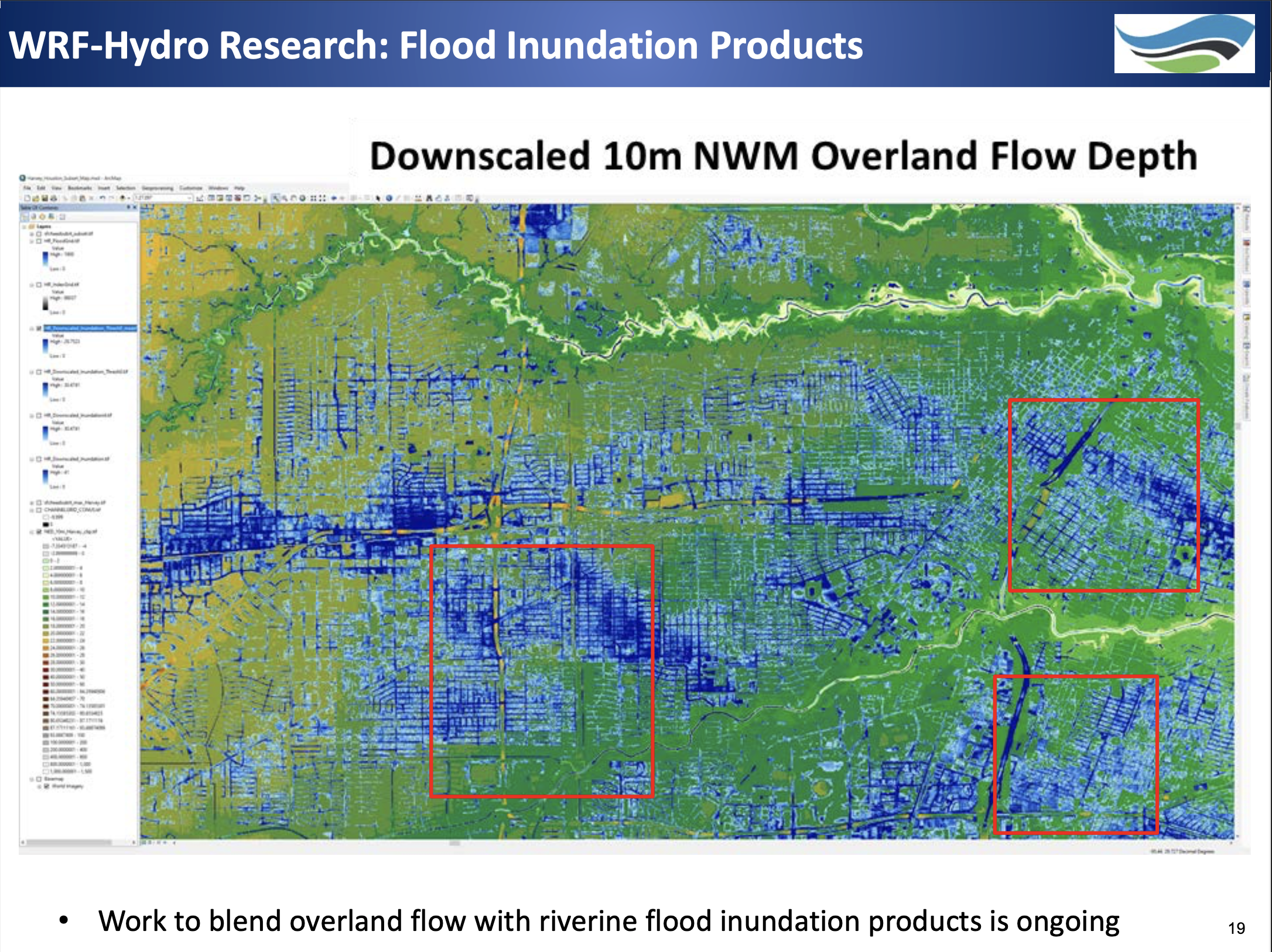
On the slides from a previous WRF-Hydro tutorial, there was mention of a 2-step hybrid blended product that includes downscaled maximum overland flow depth and riverine inundation. They also showed downscaled NWM overland flow depth maps. I attached a couple of these slides below.
Does anyone have more information on this 2-step hybrid blended product mentioned or any related techniques? Also, does anyone know how to get your model to output Overland Flow Depth?
Thanks,
Kayla

Kevin Sampson
Aug 5, 2022, 3:55:16 PM8/5/22
to wrf-hydro_users
Hi Kayla,
Thanks,
Kevin
Thanks for taking interest in the WRF-Hydro flood inundation mapping work that is going on at NCAR. The images you saw screenshots for are a downscaling of the ponded water depth. We are working on a riverine 'overbank' flow product as well. However, these are still ongoing areas of research and we have not fully developed the tools that accomplish the downscaling. We are hoping to have these finished in the near future and release them as a post-processing capability to WRF-Hydro.
I will leave your question about overland flow depth to the rest of our team.
Thanks,
Kevin
Kevin Sampson, GISP
Associate Scientist
National Center for Atmospheric Research
P.O. Box 3000 Boulder, CO  80307-3000
Tel: 303.497.8121
--
You received this message because you are subscribed to the Google Groups "wrf-hydro_users" group.
To unsubscribe from this group and stop receiving emails from it, send an email to wrf-hydro_use...@ucar.edu.
To view this discussion on the web visit https://groups.google.com/a/ucar.edu/d/msgid/wrf-hydro_users/0e0cfc9f-b83d-40b5-ae37-7cd790de48b0n%40ucar.edu.

Jana Corominas
Aug 8, 2022, 4:14:10 AM8/8/22
to wrf-hydro_users, Kevin
Hello everyone,
Flooding is a very interesting issue I've been dealing with for a while, so I really appreciate finding this topic here.
Could you give me more information about this sfcheadsubrt variable (or others) that could be usefull to study flooding?
I also was looking for models like HEC-RAS, but if WRF-Hydro already gives basic information it would be great!
How would you recommend to manage flooding just using WRF-Hydro output?
Thanks a lot,
Jana
Kayla Yamamoto
Aug 10, 2022, 2:22:11 AM8/10/22
to wrf-hydro_users, Jana Corominas, Kevin
Hi all,
Thank you Kevin for the update on some of the post-processing tools that are currently being developed by your team. I appreciate your response and am excited to utilize these tools when they are released.
Jana, from what I understand, "sfcheadsubrt" is the surface head (i.e. ponded water / standing water at the surface) on the high resolution routing grid that is included in your *RTOUT_DOMAINx files. If you have surface routing turned on, then once your surface head exceeds the local ponding retention depth for a grid cell, the excess water will be passed to the overland flow routing module. If you have channel routing turned on, then some of this will be passed to the channel routing module as well.
The problem is that the overland flow into channels is 1-way, so that there is no overbank flow out of the channel or subsurface losses. I think this means there is 'infinite' channel depth. There is a compound channel parameterization option that was recently released, but I read somewhere in the forum that the overbank flow is not 2-way interacting with the overland flow, which is what I'm looking for to create a full flood inundation surface. It looks like currently a combined inundation product would need to be computed offline somehow. **If anyone has any info on this it would be greatly appreciated!!!**
I'm not very familiar with hydraulic models, but it seems like they are useful to explicitly model the riverine overbank flooding using observations/model results as input. I don't think they include the ponded surface water, so if you're mainly interested in the riverine overbank flooding than it may be a better option.
Hopefully this helps in some way! I'm also still trying to figure out the best way to get a full inundation surface with WRF-Hydro whether that includes a combination with other models like HEC-RAS or not.
Mahalo,
Kayla
Jana Corominas
Aug 10, 2022, 2:56:45 AM8/10/22
to Kayla Yamamoto, wrf-hydro_users, Kevin
Hello Kayla, thanks for your response,
I am not sure I understood what you meant by "
infinite' channel depth", how does this 1-way flow works? I would expect WRF-Hydro model to associate a particular depth to each point and if flow exceeded this level, water would flow to neighbor cells, but you think this isn't happening, right?
Also, what do you mean by overbank flow?
I found other hidraulic related variables such as:
- swattablrt in RTOUT_DOMAIN
- depth in GWOUT_DOMAIN
- ZWT in LDASOUT_DOMAIN
- Head in CHRTOUT_DOMAIN
Thanks again,
Jana Corominas

Physicist
Modelling Department
CONFIDENTIALITY NOTICE: The contents of this email message and any attachments are intended solely
for the addressee(s) and may contain confidential and/or privileged information and may be legally
protected from disclosure. If you are not the intended recipient of this message or their agent, or
if this message has been addressed to you in error, please immediately alert the sender by reply
email and then delete this message and any attachments. If you are not the intended recipient, you
are hereby notified that any use, dissemination, copying, or storage of this message or its
attachments is strictly prohibited.
Kayla Yamamoto
Aug 10, 2022, 6:51:08 PM8/10/22
to wrf-hydro_users, Jana Corominas, wrf-hydro_users, Kevin, Kayla Yamamoto
Hi Jana,
All of the info I have is from the WRF-Hydro documents like the Tech Description available here, but I'm sure one of the experts could do a much better job at explaining.
All of the info I have is from the WRF-Hydro documents like the Tech Description available here, but I'm sure one of the experts could do a much better job at explaining.
There's a section in the tech description on channel routing physics that says "there is currently no overbank flow back to the fine-grid, so flow into the channel model is effectively one-way. Therefore, WRF-Hydro does not explicitly represent inundation areas from overbank flow from the channel back to the terrain. This will be an upcoming enhancement, though currently there are methods for post-processing an inundation surface."
I'm assuming 'overbank flow' is when the we would expect the water in the channel model to exceed bankfull.
- 'zwattablrt' is the water table depth on the high-res routing grid and is defined as the depth to saturated layers (=2m when no saturation; =0 when fully saturated)
- 'depth' is the groundwater bucket depth/water level if you're running your model with the conceptual bucket model turned on
- 'ZWT' is the depth to the water table on the land surface grid.
- 'head' is the river stage (only works for gridded channel routing)
All of the output variables and descriptions are listed here.
Thanks,
Kayla
Reply all
Reply to author
Forward
0 new messages