Making Sense of Time- Depth Curves
1,840 views
Skip to first unread message

gregsamways
Aug 22, 2017, 8:38:47 AM8/22/17
to OpendTect Users
Hi All,
I am struggling to get markers to show on well tracks. I think this is because of problems with the time-depth relationship.
I am trying to follow the instructions in the documentation, but still getting confused. For example, on the Track page of the documentation I have found the following text:
"The file containing the track information must contain the true vertical depth sub sea (Z), neither TVD nor TVD-SRD. The MD quantity (measured depth) is always referenced with respect to the reference datum elevation (thus equal to zero at KB, RT or DF)."
What does "neither TVD nor TVD-SRD" actually mean? The first part says use TVD, the second part says don't use TVD!
Also, in the Well Track import dialog I am asked to import a "Time-Depth" file and then asked "is this checkshot data"? What is the difference between a "time-depth file" and "checkshot data"? I am getting the time-depth relationship from the checkshot data, so aren't they the same thing?
Can somebody please explain what a "time depth" file should include, and why. And also what a checkshot data file should contain, and why.
Many thanks in advance.
Greg

Victoria Romanova
Aug 24, 2017, 12:07:53 PM8/24/17
to us...@opendtect.org
Hi all,
To import a well track to OpendTect the file should contain the true vertical depth sub sea (TVDSS) and KB elevation which corresponds to MD=0. There are different kinds of TVD referenced to different kinds of datums: TVDSS is referenced to mean sea level, TVD - to the well's KB, TVDSRD - to seismic reference datum. I've inserted an image explaining this in more details below:
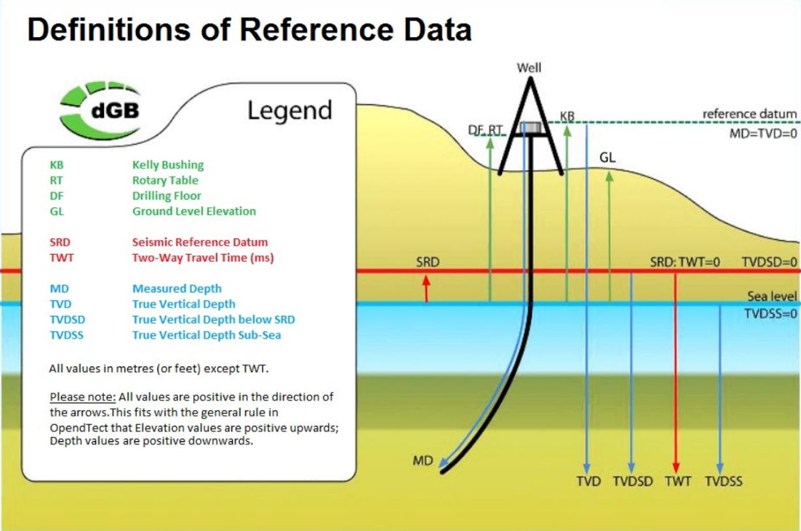
To import a well track to OpendTect the file should contain the true vertical depth sub sea (TVDSS) and KB elevation which corresponds to MD=0. There are different kinds of TVD referenced to different kinds of datums: TVDSS is referenced to mean sea level, TVD - to the well's KB, TVDSRD - to seismic reference datum. I've inserted an image explaining this in more details below:
Regarding the toggle: 'Is this check-shot data?' when importing a TD model... When selected Yes, the check-shot will simply be used for both: the 'current' TD model and the check-shot model. The idea is that the TD model can be changed during well-to-seismic tie, but the check-shot model is a constant (of course you can always import a new one or edit the check-shot model, but it's not variable in well-to-seismic tie). The TD model is then more precise as it interpolates between the check-shot model using the sonic log data. Please have a look at this page of our User's Doc for more information.
For TD model (also if it's checkshot data) you'll need to provide a time-to-depth relation model. So, the file should contain time and depth values, which usually are MD or TVDSS (TVD rel SRD is also supported) and TWT (or OWT). You could also check the well track import page for some extra info (Time-Depth model section is in the bottom of the page).
Hoping this helps.
Kind regards,
Victoria
Victoria
--
______________________________
 SEG Distinguished Achievement Award 2016
______________________________
| Victoria Romanova |
| Geoscientist |
| dGB Earth Sciences | |
| Phone: | +31 53 4315155 |
| E-mail: | victoria...@dgbes.com |
| Internet: | dgbes.com & opendtect.org |
______________________________
MICHAEL CORNYN
Sep 5, 2017, 5:05:07 PM9/5/17
to us...@opendtect.org
Victoria
Thanks for the Time-Depth Curve info. I have come up on a couple of problems that you might check into. I have installed the latest version of OpendTect (v6.0.7, revision 47802) on my mini mac (OS X 10.10.5, 12Gb memory, 2.3 Ghz Intel I7)). Software works well except for the following glitches:
1) Manual interpretation does allow picking a horizon but you can not save a useable file. First hint is that the temporary horizon name in the interpretation program can not replaced (replace horizon in tree button grayed out). The inline/xline extents of the picked horizon inline/xline area subsection are not recorded and not written by the program to the database;
2) The 3D fault and fault-stick point picking line between picked points is also not drawn unless the fault points are picked very close; and
3) The memory usage on the mac version of OD is also quite different then Windows. When loading a small volume into memory using pre-load, the listed size of the volume (MB or GB) does agree with the actual portion of free memory usage listed on my machine. Generally I am running with 0.0 free memory and everything keeps running along fine (no crashes).
I don't know if some of these issues are local to me, but I thought I would pass them onto you. I would appreciate your opinion.
Hope everything worked out for you folks in the flood.
Regards,
Mike Cornyn
--
You received this message because you are subscribed to the Google Groups "OpendTect Users" group.
To unsubscribe from this group and stop receiving emails from it, send an email to users+un...@opendtect.org.
To post to this group, send email to us...@opendtect.org.
Visit this group at https://groups.google.com/a/opendtect.org/group/users/.
To view this discussion on the web visit https://groups.google.com/a/opendtect.org/d/msgid/users/CA%2B8VRTYiUwHbexPr2p-QTBjPx4qDsow93KwTtYUbMrRcpOqJQQ%40mail.gmail.com.
For more options, visit https://groups.google.com/a/opendtect.org/d/optout.
Victoria Romanova
Sep 6, 2017, 5:55:55 AM9/6/17
to us...@opendtect.org
Hi all,
These issues have been forwarded to support and handled from there.

Julien Moreau
Sep 7, 2017, 3:30:22 AM9/7/17
to us...@opendtect.org
Hello,
Some suggestions from a user.
For 1) How did you install the software? did you log as superuser to run the installation script? Did you install it in your home? Seems to me that your software is not allowed to write where you want.Good luck,
Julien
To unsubscribe from this group and stop receiving emails from it, send an email to users+unsubscribe@opendtect.org.
To post to this group, send email to us...@opendtect.org.
Visit this group at https://groups.google.com/a/opendtect.org/group/users/.
To view this discussion on the web visit https://groups.google.com/a/opendtect.org/d/msgid/users/CA%2B8VRTYiUwHbexPr2p-QTBjPx4qDsow93KwTtYUbMrRcpOqJQQ%40mail.gmail.com.
For more options, visit https://groups.google.com/a/opendtect.org/d/optout.
--
You received this message because you are subscribed to the Google Groups "OpendTect Users" group.
To unsubscribe from this group and stop receiving emails from it, send an email to users+unsubscribe@opendtect.org.
To post to this group, send email to us...@opendtect.org.
Visit this group at https://groups.google.com/a/opendtect.org/group/users/.
To view this discussion on the web visit https://groups.google.com/a/opendtect.org/d/msgid/users/2073138247.3180915.1504627333914%40mail.yahoo.com.
--
======
Julien Moreau, PhD, MSc, MSc
The NW-Edge
Basin Analyst
Independent researcher in geology and applied geophysics
SAS rep - North West Scotland - Scotland & Hebrides Rep
5 Hames Place, Durness, Lairg
IV27 4PR United Kingdom
Mobile: +44 (0) 746 20 781 62
Home: +44 (0) 131 61 869 29
Julien Moreau, PhD, MSc, MSc
The NW-Edge
Basin Analyst
Independent researcher in geology and applied geophysics
SAS rep - North West Scotland - Scotland & Hebrides Rep
5 Hames Place, Durness, Lairg
IV27 4PR United Kingdom
Mobile: +44 (0) 746 20 781 62
Home: +44 (0) 131 61 869 29
Reply all
Reply to author
Forward
0 new messages