New user, how to do time-depth conversion for a single 2D line

Md Ariful Islam

satyesh bhandari
Hi,
Without the velocity information of sedimentary layer it is not possible to convert a time section into a depth section.
However, to get a simple depth section there is way around. Prepare a layered velocity model. Just correlate water bottom reflector and any two other strong reflectors. Even a water bottom reflector is sufficient if you don’t have other. Apply a velocity of 1500 m/s for water layer and about 2000 m/s for sedimentary layer. The depth error will be in the range of +/- 1-2 percent for shallow targets and about 5 percent for deeper targets for more than 2000 mts.
--
You received this message because you are subscribed to the Google Groups "OpendTect Users" group.
To unsubscribe from this group and stop receiving emails from it, send an email to users+un...@opendtect.org.
To view this discussion on the web visit https://groups.google.com/a/opendtect.org/d/msgid/users/d8611fee-506e-4ff0-8cdb-bdc53d0a1bbfn%40opendtect.org.
Md Ariful Islam
.png?part=0.2&view=1)


MICK
Do you have horizons picked for the various boundaries sea floor, base sediment , base crust?
If so depth is :
seafloor TWT/2*1.5 +( base sed TWT- Seafloor TWT)/2*2.2 + (twt – Base sed tWT)*6.5
You don’t need opendtect for this – you can do it in excel.
To view this discussion on the web visit https://groups.google.com/a/opendtect.org/d/msgid/users/e9cdb2cf-b32e-49e9-81c1-2eb0c11c3185n%40opendtect.org.

lviertel
Hi,
Maybe this is useful to you.
I would do it in a quick way as follows:
Create your velocity model using 3 colors in any paint package you like. Make sure you keep scale and proportions. You can take an image of the line and paint on top.
Load your image into matlab.
convert image to segy using matlab script "image2segy". You need to know the navigation or extract from the original segy.
if you know well matlab change value of color A by velocity of layer 1, value of color B by velocity of layer 2, value if color C by velocity of layer 3 and export the segy (you will need to tweak the script a bit)
or
export the segy and load load into matlab again using any seismic package like seislab, and then replace from segy value of color A by velocity of layer 1, value of color B by velocity of layer 2, value if color C by velocity of layer 3. You need to work with 16 or 32 bit floats as 6500 m/sec is larger than 256 (8 bit)
export again and load into opendtect as a segy velocity line
Hope this helps.
Once done once is more easy than it looks.
Cheers,
Luis
At 09:26 PM 10/11/2021, Md Ariful Islam wrote:
Hello,
Thank you very much sir for your reply. I'm very new with seismic data that's why probably having a hard time doing this.
I am assuming 3 velocity values for three layers ( water - 15km/s, sedimentary layer 2.2km/s and crust 6.5km/s).
But I don't know how to create a velocity model from that for Time-Depth conversion.
Could you or anyone else please give me a little hint how to so this in OpendTect.
Thank you very much.
![Screenshot (2).png]()
![OpendTect 2d.PNG]()
On Sunday, October 3, 2021 at 4:58:22 AM UTC-5 satyesh.bhandari wrote:
- Hi,
- Without the velocity information of sedimentary layer it is not possible to convert a time section into a depth section.
- However, to get a simple depth section there is way around. Prepare a layered velocity model. Just correlate water bottom reflector and any two other strong reflectors. Even a water bottom reflector is sufficient if you don’t have other. Apply a velocity of 1500 m/s for water layer and about 2000 m/s for sedimentary layer. The depth error will be in the range of +/- 1-2 percent for shallow targets and about 5 percent for deeper targets for more than 2000 mts.
- Â
- From: Md Ariful Islam <arif94...@gmail.com>
- Sent: 02 October 2021 23:53
- To: OpendTect Users <us...@opendtect.org>
- Subject: [OpendTect_Users] New user, how to do time-depth conversion for a single 2D line
- Â
- Hi,
- I only have two 2D seismic lines and average velocity values for water column, sedimentary layers and crystalline basement. Now I need to convert the image into depth domain. I am very new in this, I tried opendtect youtube tutorials but I couldn't find one. I tried creating velocity models but I failed. Please help me with your expertise.
- I'm linking one of the lines because these files are kind of different than other files I tried to open. I can't open them in the main window, it opens only in 2D viewer option.
- --
- You received this message because you are subscribed to the Google Groups "OpendTect Users" group.
- To unsubscribe from this group and stop receiving emails from it, send an email to users+un...@opendtect.org.
- To view this discussion on the web visit https://groups.google.com/a/opendtect.org/d/msgid/users/d8611fee-506e-4ff0-8cdb-bdc53d0a1bbfn%40opendtect.org .
--
You received this message because you are subscribed to the Google Groups "OpendTect Users" group.
To unsubscribe from this group and stop receiving emails from it, send an email to users+un...@opendtect.org.
To view this discussion on the web visit https://groups.google.com/a/opendtect.org/d/msgid/users/e9cdb2cf-b32e-49e9-81c1-2eb0c11c3185n%40opendtect.org .
Content-Type: image/png; name="OpendTect 2d.PNG"
Content-Disposition: inline; filename="OpendTect 2d.PNG"
X-Attachment-Id: 39b294b5-fd61-419b-931e-9fb2afa2174d
Content-ID: <39b294b5-fd61-419b-931e-9fb2afa2174d>
Content-Type: image/png; name="Screenshot (2).png"
Content-Disposition: inline; filename="Screenshot (2).png"
X-Attachment-Id: b665902a-c9e6-470d-a31d-6c02bd6847d0
Content-ID: <b665902a-c9e6-470d-a31d-6c02bd6847d0>
Luis Viertel | Operations Manager
Lu...@gulfsolartech.com
| Cell (Dubai): +97150 647 7169
Tel: +9714 882 9072 Ext.: 132 | Fax: +9714
883 5072
Gulf Solar Technologies LLC
| P. O. Box 6254 – Dubai, UAE |
www.gulfsolartech.com
MICK
Don’t forget the /2 at the end of the formula
From: MICK [mailto:mic...@bigpond.com]
Sent: Tuesday, 12 October 2021 3:48 PM
To: us...@opendtect.org
Subject: RE: [OpendTect_Users] New user, how to do time-depth conversion for a single 2D line
Do you have horizons picked for the various boundaries sea floor, base sediment , base crust?
If so depth is :
seafloor TWT/2*1.5 +( base sed TWT- Seafloor TWT)/2*2.2 + (twt – Base sed tWT)*6.5/2
To view this discussion on the web visit https://groups.google.com/a/opendtect.org/d/msgid/users/000c01d7bf3d%2483093d10%24891bb730%24%40bigpond.com.
MICK
Further to my previous reply try
Analysis-> velocity model building à horizon based velocity model (or similar – I cant recall the exact headings)
From: Md Ariful Islam [mailto:arif94...@gmail.com]
Sent: Tuesday, 12 October 2021 1:26 AM
To: OpendTect Users <us...@opendtect.org>
Cc: satyesh.bhandari <satyesh....@gmail.com>
To view this discussion on the web visit https://groups.google.com/a/opendtect.org/d/msgid/users/e9cdb2cf-b32e-49e9-81c1-2eb0c11c3185n%40opendtect.org.

Mark Crawford
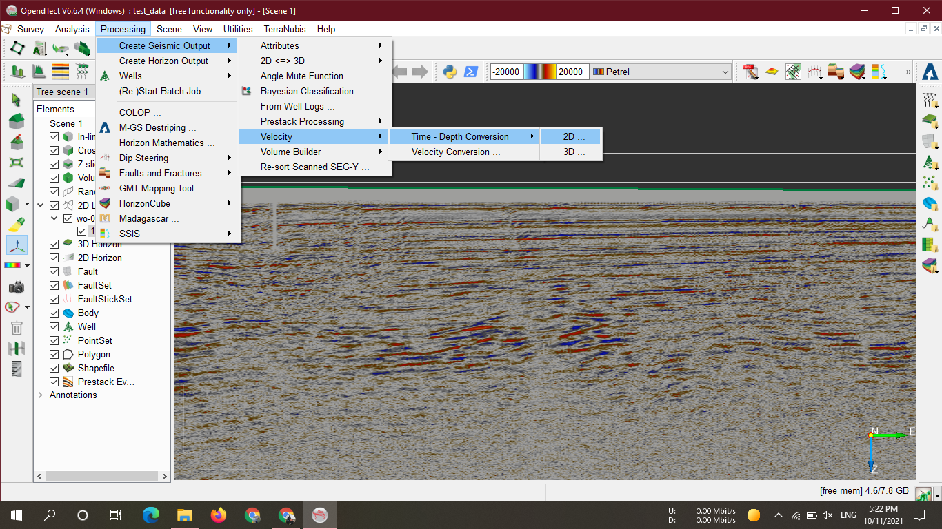
Once here, you toggle 'Time to Depth' and select the Simple Time-Depth model from the Z transform dropdown and press 'Create':Processing > Create Seismic Output > Velocity > Time-Depth Conversion > 2D...
![2021-10-12 11_22_47-OpendTect Pro V6.6.5rc5 (Windows) _ F3 Demo 2020 [free project] - [Scene 1].png](https://groups.google.com/a/opendtect.org/group/users/attach/5168f7bd21def/2021-10-12%2011_22_47-OpendTect%20Pro%20V6.6.5rc5%20(Windows)%20%20_%20F3%20Demo%202020%20%20%5Bfree%20project%5D%20-%20%5BScene%201%5D.png?part=0.1&view=1)
![2021-10-12 11_57_57-OpendTect Pro V6.6.5rc5 (Windows) _ F3 Demo 2020 [free project].png](https://groups.google.com/a/opendtect.org/group/users/attach/5168f7bd21def/2021-10-12%2011_57_57-OpendTect%20Pro%20V6.6.5rc5%20(Windows)%20%20_%20F3%20Demo%202020%20%20%5Bfree%20project%5D.png?part=0.2&view=1)
--
You received this message because you are subscribed to the Google Groups "OpendTect Users" group.
To unsubscribe from this group and stop receiving emails from it, send an email to users+un...@opendtect.org.
To view this discussion on the web visit https://groups.google.com/a/opendtect.org/d/msgid/users/d8611fee-506e-4ff0-8cdb-bdc53d0a1bbfn%40opendtect.org.
| Support Manager |

| ----------------------------------------------------------------------------------------------------------------------- dGB Earth Sciences | |||||||
| |||||||
Md Ariful Islam

Paul de Groot
| Geoscience Manager |
| ----------------------------------------------------------------------------------------------------------------------- dGB Earth Sciences | |||||||
| |||||||
To view this discussion on the web visit https://groups.google.com/a/opendtect.org/d/msgid/users/2aaf6ba9-bac9-4dca-9040-8e880ac2f0e7n%40opendtect.org.