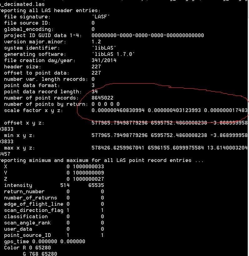
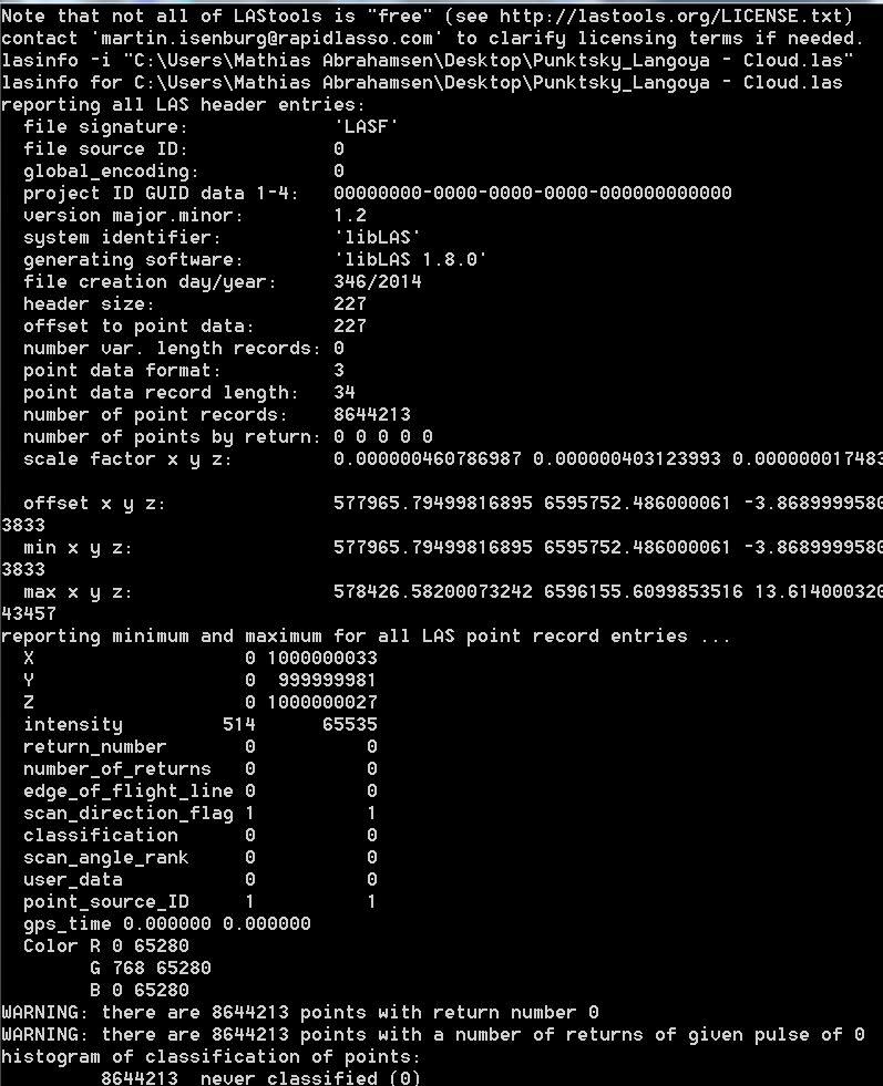
Scale factor x,y, z, LAS-file, what is it?

Mathias Abrahamsen

Jakub Krawczyk
|
|
|
|
|
OPEGIEKA
Sp. z o.o., al. Tysiąclecia 11, 82-300 Elbląg, Poland, www.opegieka.pl |
--
Download LAStools at
http://lastools.org
http://rapidlasso.com
Be social with LAStools at
http://facebook.com/LAStools
http://twitter.com/LAStools
http://linkedin.com/groups/LAStools-4408378
Manage your settings at
http://groups.google.com/group/lastools/subscribe

Antoine Cottin
--
Download LAStools at
http://lastools.org
http://rapidlasso.com
Be social with LAStools at
http://facebook.com/LAStools
http://twitter.com/LAStools
http://linkedin.com/groups/LAStools-4408378
Manage your settings at
http://groups.google.com/group/lastools/subscribe
Dr Antoine Cottin
Chief Technology Officer
7th Floor, Appleton Tower
11 Crichton Street
Edinburgh
EH8 9LE

Lewis Graham
Lewis Graham
GeoCue Group
9668 Madison Blvd., Suite 202
Madison, AL USA 35758
01-256-461-8289
Mathias Abrahamsen

Antoine Cottin

Dimitri Lague
Hi,
The latest version of Cloudcompare 2.6.0 has updated to the latest version of liblas who’s in charge of I/O for las files. There was indeed some problems saving .las files in the previous versions. If the bug is still there, could someone post it in the Cloudcompare forum for correction in the next release ? The .las I/O capabilities of Cloudcompare was a request from users, but Daniel Girardeau-Montaut the main developer does not use a lot, so small bugs not directly visible when loading the file may skip its attention.
Thanks in advance
Dimitri
----------------------------------------------------------------------------------------------
Dr Dimitri Lague, Chargé de Recherche CNRS, Quantitative Geomorphology
Géosciences Rennes, UMR 6118 CNRS
Université Rennes 1, Campus de Beaulieu
35042 Rennes Cedex - FRANCE
Tel : +33 (0) 223235653
Fax : +33 (0) 223234375
www : http://www.geosciences.univ-rennes1.fr/spip.php?rubrique95
Laser scanning webpages: http://www.geosciences.univ-rennes1.fr/spip.php?article1125
-------------------------------------------------------------------------------------------------------
De : last...@googlegroups.com [mailto:last...@googlegroups.com] De la part de Antoine Cottin
Envoyé : Saturday, 13 December 2014 12:59
À : last...@googlegroups.com
Objet : Re: [LAStools] Scale factor x,y, z, LAS-file, what is it?

Mathias Abrahamsen

Daniel Girardeau-Montaut
- that CloudCompare remembers the original offset/scale information when loading the cloud from a LAS file? (the issue is that if you modify the values inside CC, this information might not be adapted to the new coordinates of the cloud)
- or that CloudCompare asks the user for the right offset/scale values when saving the file? (in a kind of 'advanced mode' of course)
Mathias Abrahamsen

Dr Antoine Cottin
Envoyé de mon iPhone
Mathias Abrahamsen
...
Daniel Girardeau-Montaut
Mathias Abrahamsen
Daniel Girardeau-Montaut

Steven F
Daniel Girardeau-Montaut
--

Martin Isenburg
Hello Daniel,
> About the "compressibilty", I'll be
> interested by the test results. I don't
> expect a real difference though
I expect (and have witnessed) an enourmous difference in compression. The LAS formats stores the points quantized to a suitable resolution, usually centimeters (0.01) or millimeters (0.001). That means the range of integer numbers that needs to be compressed for coordinates ranging - for example - from -1.27 to 25.92 is exactly -127 to 2592 ... namely 2720 different possible values whose differences will be small. If you change the scale factor so that the coordinates range from 0 to 1000000000 instead then we suddenly have 1000000000 different possible values whose differences will be huge (and much more bit-costly to compress).
> Maybe LAZ files use the scale
> information to deduce a kind of
> absolute accuracy to shrink down the
> coordinates? I don't think so as I
> believe it is a loss-less compression.
Yes, LAZ is lossless. It compresses the coordinates at whatever scale they are. Adding "resolution fluff" (e.g. several low-order bits whose content is determined solely by whatever the floating-point arithmetic on inflated scale values puts here) results in larger correction vectors that compress less good. The same loss in compression happens when storing cm rounded points with mm precision (e.g. changing the scale factor from 0.01 to 0.001 while at the same time multiplying all integer coordinates with 10).
> Even if there's no bug in CC, I still think
> we should add an 'advanced options'
> dialog for LAS saving so that people
> requiring particular values for the offset
> and scale can specify their own.
Good idea. Also for all other formats as winzipping or gzipping a PLY, OBJ, PTS or PTX with "resolution fluff" suffers the same lowered compression translating into bulkier storage, more IO, and higher CPU usage as all these uncompressible low-order bits will have to be read back in, decompressed, and - for ASCII formats - also be translated.
Have a look at http://pointzip.org that is a variant of http://laszip.org to compress PTS and PTX files. Offering the option to scale the output results in much "nicer" and less bulky ASCII PTS and PTX files after decompression than the standard 6 decimal digits (micrometer resolution) output by Cyclone.
Remember the diameter of a human hair ranges from 40 to 120 micrometer to the scanned points. Hence the scanned measurements exported by Cyclone have - in theory - enough resolution to compute the exact total hair volume as well as perform a hair brittleness analysis for any perdon who was scanned. But - in practice - neither the density of pulses, nor the laser beam width, nor the ranging accuracy produce points that have micrometer accuracy. Exporting them with micrometer resolution may be a convenient way to be überconservative ... but produces gigantic ASCII files that do not compress well.
I can not even imagine the world-wide savings in storage hardware, network bandwidth, and computation power over the past 20 years if Cyclone would have exported only 4 decimal digits for each coordinate ... maybe we would have a human colony on Mars already. (-;
Regards,
Martin @rapidlasso
Daniel Girardeau-Montaut
--