Quebec going Open Data in Fall 2016

302 views
Skip to first unread message

Martin Isenburg

unread,
May 4, 2016, 12:11:39 PM5/4/16
to LAStools - efficient command line tools for LIDAR processing

Hello from Quebec City,

Archaeogists, biologists, hydrologists, geologists, ... will rejoice at these news. Today at a LiDAR workshop at University of Laval, Antoine Lebœuf from the Ministère des Forêts, de la Faune et des Parcs (MFFP) of the Province of Quebec has announced that the 200,000 square km of existing LiDAR will become Open Data with free download for several derived products:

* 1m DTM
* 2m slope map
* 1m hillshade
* and another forestry product.

Furthermore MFFP Quebec plans full coverage on the entire provice of  by 2022 by aquiring 70,000 square km a year of the remaining 300,000 square km at a density of 1.5 and 2.5 pulses per square meter depending on the dominant forest type.

Congrats to the Province of Quebec for leading Canada towards the benefits of open LiDAR data  ... (-;

I'd like to finish with a quote from Arnulf Christl (@sevenspatial): "If geospatial data was sand then opening it gives us concrete, houses, windows, beach bars, ... "

Regards,

Martin @rapidlasso

Chnhj0gWEAAxA-F.jpg

Nicolas Cadieux

unread,
May 4, 2016, 3:34:29 PM5/4/16
to last...@googlegroups.com

Very interesting.

I will believe it when I see it!  Hopefully, they will have the same response with the rest of the provincial geospatial data currently being sold.  Opening this data is the way to go! 

Thanks for the good new!

Nicolas

Francois Joyal

unread,
May 6, 2016, 10:39:02 AM5/6/16
to LAStools - efficient tools for LiDAR processing
WOW! What a great new! It's gone to be very helpful for us.

Merci au MFFP

Eric Callender

unread,
Aug 16, 2016, 1:21:54 PM8/16/16
to LAStools - efficient tools for LiDAR processing


Dear Mr. Isenburg,
 
Greetings from Whistler, BC, Canada.  I have been scouring the internet for Lidar (bare earth) data for Quebec and I've stumbled across your post. I have been unable to find any other source or government (MFFP) news release which references or announces the pending Open Data release, which is hopefully soon!  I only found your post again on twitter, which includes a photo of the presentation that you attended.  Seems this is still almost a secret in Canada (admittedly, I’m searching in English so perhaps there are French language news releases which have escaped my searches).

Do you by chance have any links or contacts regarding this pending Open Source release? 
Any advice or confirmation of the expected release date would be very much appreciated.

Best regards,

Eric

Martin Isenburg

unread,
Aug 17, 2016, 8:20:15 AM8/17/16
to LAStools - efficient command line tools for LIDAR processing
Hello,

Eric got back to me. Turns out 45 minutes after his email to the LAStools user forum he was forwarded the announcement made on July 19th and again on August 2nd (but in French only). Eric has since located and downloaded the data that he was hoping for and has apparently done his happy dance (so he writes). He also hopes that now it’s time for the rest of the provinces to follow suit!  Canadian TRIM mapping is apparently too low resolution for his work, so he likes to source LiDAR whenever it’s available. See below for the link and - if needed - run google translate to read the announcement further below.


The data is now accessible via

http://geoegl.msp.gouv.qc.ca/igo/mffpecofor/


cid:image002.png@01D1F7C3.2FEAB790


=========================================================

cid:image001.png@01D1ECA4.789557E0QUEBw2

diese563_acrigeo_logo-[Converti]

2 août 2016


Carte interactive et service de cartographie Web (WMS) des données écoforestières du Québec   


cid:image005.jpg@01D1F7C4.34A00CD0La Direction des inventaires forestiers du ministère des Forêts, de la Faune et des Parcs (MFFP) est heureuse de vous informer qu’une carte interactive et un service de cartographie Web (WMS) présentant les données écoforestières du Québec sont maintenant accessibles à tous! Fini le temps où il était impossible de visualiser la carte écoforestière en ligne!


Ces services Web (infrastructure de service et interface de cartographie) sont constitués de divers logiciels libres (Open source) et maintenus par la communauté interministérielle IGO (Infrastructure Géographique Ouverte).


La carte interactive présente une interface conviviale qui donne un aperçu global et à jour des produits et des données écoforestières du Québec, dont la carte écoforestière. Il est possible de visualiser et d’interroger chaque élément, d’en obtenir une description simplifiée et de créer des cartes personnalisées. De plus, cette carte interactive permet le téléchargement de certaines données actuellement diffusées gratuitement (ex. : classification écologique du territoire québécois). Ces données gratuites sont aussi téléchargeables sur le site des données ouvertes du gouvernement du Québec Données Québec. Lorsque l’accès à la donnée est payant (ex. : carte écoforestière), la façon d’y accéder est détaillée dans la fiche descriptive du produit.


cid:image007.png@01D1F7C4.34A00CD0Une fois les données écoforestières diffusées sur le Web, elles peuvent être récupérées et intégrées à d’autres logiciels d’information géographique (SIG) ou à un SIG Web (solution en ligne).  L’adresse URL de ce service de cartographie Web (WMS) est maintenant offerte à tous. Cependant, son utilisation optimale nécessite des connaissances spécifiques en informatique et il s’adresse à une clientèle plus spécialisée. Cette solution portable permet une consultation en temps réel dans une application SIG des données écoforestières du Québec. Ce service répond aux standards OGC (Open Geospatial Consortium).


C’est facile ! un seul clic pour y accéder.


Pour toute question, n’hésitez pas à communiquer avec la Direction des inventaires forestiers du MFFP ou à vous inscrire à l’infolettre. Vous pouvez également partager vos commentaires et questions sur laCommunauté de pratique en information géographique, pour le bénéfice de tous!


Carte interactive et service de cartographie Web (WMS) des données écoforestières du Québec   
 
cid:image0...@01D1F7C4.34A00CD0La Direction des inventaires forestiers du ministère des Forêts, de la Faune et des Parcs (MFFP) est heureuse de vous informer qu’une carte interactive et un service de cartographie Web (WMS) présentant les données écoforestières du Québec sont maintenant accessibles à tous! Fini le temps où il était impossible de visualiser la carte écoforestière en ligne!
 
Ces services Web (infrastructure de service et interface de cartographie) sont constitués de divers logiciels libres (Open source) et maintenus par la communauté interministérielle IGO (Infrastructure Géographique Ouverte).
 
La carte interactive présente une interface conviviale qui donne un aperçu global et à jour des produits et des données écoforestières du Québec, dont la carte écoforestière. Il est possible de visualiser et d’interroger chaque élément, d’en obtenir une description simplifiée et de créer des cartes personnalisées. De plus, cette carte interactive permet le téléchargement de certaines données actuellement diffusées gratuitement (ex. : classification écologique du territoire québécois). Ces données gratuites sont aussi téléchargeables sur le site des données ouvertes du gouvernement du Québec Données Québec. Lorsque l’accès à la donnée est payant (ex. : carte écoforestière), la façon d’y accéder est détaillée dans la fiche descriptive du produit.
 
cid:image0...@01D1F7C4.34A00CD0Une fois les données écoforestières diffusées sur le Web, elles peuvent être récupérées et intégrées à d’autres logiciels d’information géographique (SIG) ou à un SIG Web (solution en ligne).  L’adresse URL de ce service de cartographie Web (WMS) est maintenant offerte à tous. Cependant, son utilisation optimale nécessite des connaissances spécifiques en informatique et il s’adresse à une clientèle plus spécialisée. Cette solution portable permet une consultation en temps réel dans une application SIG des données écoforestières du Québec. Ce service répond aux standards OGC (Open Geospatial Consortium).
 
C’est facile ! un seul clic pour y accéder.
 

Martin Isenburg

unread,
Aug 19, 2016, 8:05:36 AM8/19/16
to LAStools - efficient tools for LiDAR processing
Hello,

I was curious about seeing some French-Canadian LiDAR point clouds so I went to 

http://geoegl.msp.gouv.qc.ca/igo/mffpecofor/

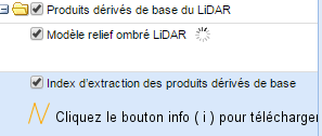
but was not able to find any raw point clouds. All I could find was precomputed TIF rasters (DTM, DSM, and CHM) as well as hillshades. Am I looking in the wrong area where the raw point cloud is not published yet? See the attached image where I looked.

Regards,

Martin @rapidlasso

PS: A little bird told me that New Brunswick will soon publish their LiDAR holdings, including raw point clouds as over 26,000 LAZ files, on a web server for free download under the GeoNB Open Data license. It's an open data race of Olympic dimensions. Which province will come in first and take the Canadian Gold in the competition for maximal LiDAR openness ... ? (-;
open_lidar_quebec.jpg

Dave....@mffp.gouv.qc.ca

unread,
Aug 19, 2016, 8:33:48 AM8/19/16
to last...@googlegroups.com

Hello,


No, unfortunately the point cloud is not published yet. There are no short-term forecasting publication. This is a step in the right direction but there is still some way to go…


Regards !

Dave Munger

Analyste en géomatique et LiDAR


dave....@mffp.gouv.qc.ca
mffp.gouv.qc.ca


De : last...@googlegroups.com [mailto:last...@googlegroups.com] De la part de Martin Isenburg
Envoyé : 19 août 2016 08:04
À : LAStools - efficient tools for LiDAR processing
Objet : Re: [LAStools] Re: Quebec going Open Data in Fall 2016

--

Nicolas Cadieux

unread,
Aug 23, 2016, 2:03:33 PM8/23/16
to last...@googlegroups.com, ericgca...@gmail.com
Hi Eric,

I work in Quebec with a lot with Lidar.  Don't know the progress Open Data thing  but I have lots of data for Québec but most is proprietary but some is Open Data.  What area are you looking for?  I may be able to point you in the right direction. 

Nicolas

Envoyé de mon iPad
--

Martin Isenburg

unread,
Sep 2, 2016, 11:07:41 AM9/2/16
to LAStools - efficient tools for LiDAR processing, ericgca...@gmail.com, nicolas...@archeotec.ca
Hello,

there is a lot of open LiDAR for download in Montreal:


I have downloaded one tile (see screenshot) and while the points look great there is an issue with the return numbering ... it is not specification conform so expect a number of LiDAR processing operations that rely on correct last / first / intermediate return labelling to miss-behave. The validation report and a lasinfo report is attached as well as a few visualizations of the downloaded tile.

Regards,

Martin @rapidlasso
open_lidar_montreal.png
293-5041_2015_2-5-6_info.txt
293-5041_2015_2-5-6_validate.xml
open_lidar_montreal_1.jpg
open_lidar_montreal_4.jpg
open_lidar_montreal_3.jpg
open_lidar_montreal_2.jpg

Steeve Brissette

unread,
Dec 16, 2017, 8:14:54 PM12/16/17
to LAStools - efficient tools for LiDAR processing
Hi all, for those who wish to get free Lidar data in Canada (Listed by Provinces), here is the best link you can get, enjoy!


Steeve
Reply all
Reply to author
Forward
0 new messages